You are here: Home > Network List > TA - USArray Transportable Network (new EarthScope stations) Stations List
> Station O33A Hebron, NE, USA > Earthquake Result Viewer
O33A Hebron, NE, USA - Earthquake Result Viewer
| Earthquake location: |
Off East Coast Of Kamchatka |
| Earthquake latitude/longitude: |
52.5/159.8 |
| Earthquake time(UTC): |
2010/07/30 (211) 03:56:13 GMT |
| Earthquake Depth: |
23 km |
| Earthquake Magnitude: |
6.1 MB, 6.3 MS, 6.3 MW, 6.3 MW |
| Earthquake Catalog/Contributor: |
WHDF/NEIC |
|
| Network: |
TA USArray Transportable Network (new EarthScope stations) |
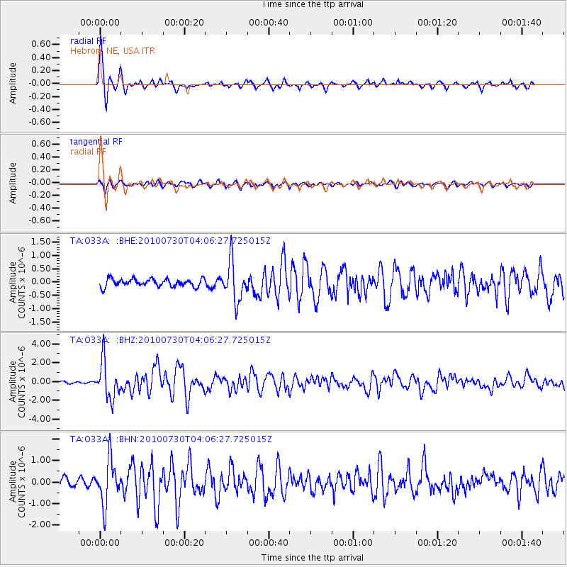
| Station: |
O33A Hebron, NE, USA |
| Lat/Lon: |
40.08 N/97.58 W |
| Elevation: |
480 m |
|
| Distance: |
66.1 deg |
| Az: |
55.009 deg |
| Baz: |
319.252 deg |
| Ray Param: |
0.0578178 |
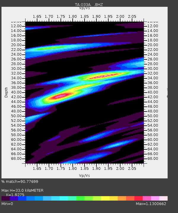
| Estimated Moho Depth: |
33.0 km |
| Estimated Crust Vp/Vs: |
1.93 |
| Assumed Crust Vp: |
6.498 km/s |
| Estimated Crust Vs: |
3.371 km/s |
| Estimated Crust Poisson's Ratio: |
0.32 |
|
| Radial Match: |
90.77699 % |
| Radial Bump: |
322 |
| Transverse Match: |
67.321465 % |
| Transverse Bump: |
400 |
| SOD ConfigId: |
319893 |
| Insert Time: |
2011-01-05 14:58:40.574 +0000 |
| GWidth: |
2.5 |
| Max Bumps: |
400 |
| Tol: |
0.001 |
|
Signal To Noise
| Channel | StoN | STA | LTA |
| TA:O33A: :BHZ:20100730T04:06:27.725015Z | 18.09475 | 2.0076723E-6 | 1.10953295E-7 |
| TA:O33A: :BHN:20100730T04:06:27.725015Z | 4.612003 | 1.0549043E-6 | 2.287302E-7 |
| TA:O33A: :BHE:20100730T04:06:27.725015Z | 5.3141146 | 7.5665264E-7 | 1.4238546E-7 |
| Arrivals |
| Ps | 4.9 SECOND |
| PpPs | 14 SECOND |
| PsPs/PpSs | 19 SECOND |


