You are here: Home > Network List > AZ - ANZA Regional Network Stations List
> Station BVDA2 AZ.BVDA2 > Earthquake Result Viewer
BVDA2 AZ.BVDA2 - Earthquake Result Viewer
| Earthquake location: |
Chile-Bolivia Border Region |
| Earthquake latitude/longitude: |
-22.3/-67.9 |
| Earthquake time(UTC): |
2005/11/17 (321) 19:26:56 GMT |
| Earthquake Depth: |
163 km |
| Earthquake Magnitude: |
6.0 MB, 6.9 MW, 6.8 MW |
| Earthquake Catalog/Contributor: |
WHDF/NEIC |
|
| Network: |
AZ ANZA Regional Network |
| Station: |
BVDA2 AZ.BVDA2 |
| Lat/Lon: |
33.33 N/116.37 W |
| Elevation: |
0.0 m |
|
| Distance: |
72.1 deg |
| Az: |
318.795 deg |
| Baz: |
133.233 deg |
| Ray Param: |
0.053460438 |
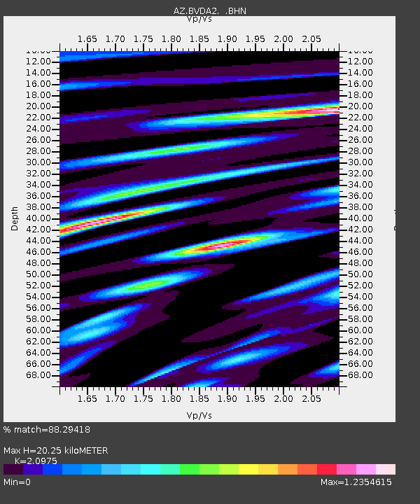
| Estimated Moho Depth: |
20.25 km |
| Estimated Crust Vp/Vs: |
2.10 |
| Assumed Crust Vp: |
6.264 km/s |
| Estimated Crust Vs: |
2.986 km/s |
| Estimated Crust Poisson's Ratio: |
0.35 |
|
| Radial Match: |
88.29418 % |
| Radial Bump: |
400 |
| Transverse Match: |
68.532906 % |
| Transverse Bump: |
400 |
| SOD ConfigId: |
2422 |
| Insert Time: |
2010-02-26 18:38:46.605 +0000 |
| GWidth: |
2.5 |
| Max Bumps: |
400 |
| Tol: |
0.001 |
|
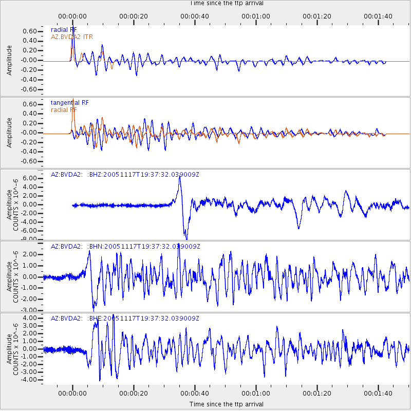
Signal To Noise
| Channel | StoN | STA | LTA |
| AZ:BVDA2: :BHN:20051117T19:37:32.039009Z | 2.1450763 | 4.212332E-7 | 1.9637213E-7 |
| AZ:BVDA2: :BHE:20051117T19:37:32.039009Z | 1.7605801 | 3.8971712E-7 | 2.2135723E-7 |
| AZ:BVDA2: :BHZ:20051117T19:37:32.039009Z | 8.189632 | 1.4924916E-6 | 1.8224158E-7 |
| Arrivals |
| Ps | 3.6 SECOND |
| PpPs | 9.7 SECOND |
| PsPs/PpSs | 13 SECOND |


