You are here: Home > Network List > AZ - ANZA Regional Network Stations List
> Station BVDA2 AZ.BVDA2 > Earthquake Result Viewer
BVDA2 AZ.BVDA2 - Earthquake Result Viewer
| Earthquake location: |
Hokkaido, Japan Region |
| Earthquake latitude/longitude: |
42.9/144.9 |
| Earthquake time(UTC): |
2005/01/18 (018) 14:09:06 GMT |
| Earthquake Depth: |
42 km |
| Earthquake Magnitude: |
6.3 MB, 5.7 MS, 6.3 MW, 6.2 MW |
| Earthquake Catalog/Contributor: |
WHDF/NEIC |
|
| Network: |
AZ ANZA Regional Network |
| Station: |
BVDA2 AZ.BVDA2 |
| Lat/Lon: |
33.33 N/116.37 W |
| Elevation: |
0.0 m |
|
| Distance: |
73.9 deg |
| Az: |
59.461 deg |
| Baz: |
310.943 deg |
| Ray Param: |
0.05262995 |
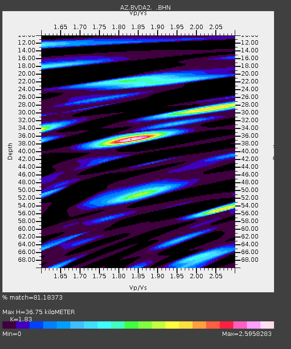
| Estimated Moho Depth: |
36.75 km |
| Estimated Crust Vp/Vs: |
1.83 |
| Assumed Crust Vp: |
6.264 km/s |
| Estimated Crust Vs: |
3.423 km/s |
| Estimated Crust Poisson's Ratio: |
0.29 |
|
| Radial Match: |
81.18373 % |
| Radial Bump: |
400 |
| Transverse Match: |
77.03678 % |
| Transverse Bump: |
400 |
| SOD ConfigId: |
5233 |
| Insert Time: |
2010-02-26 18:38:47.498 +0000 |
| GWidth: |
2.5 |
| Max Bumps: |
400 |
| Tol: |
0.001 |
|

Signal To Noise
| Channel | StoN | STA | LTA |
| AZ:BVDA2: :BHN:20050118T14:20:05.85501Z | 1.8397868 | 2.3514092E-7 | 1.2780879E-7 |
| AZ:BVDA2: :BHE:20050118T14:20:05.85501Z | 2.1730044 | 2.2228635E-7 | 1.0229448E-7 |
| AZ:BVDA2: :BHZ:20050118T14:20:05.85501Z | 5.6792984 | 4.372969E-7 | 7.6998404E-8 |
| Arrivals |
| Ps | 5.0 SECOND |
| PpPs | 16 SECOND |
| PsPs/PpSs | 21 SECOND |


