You are here: Home > Network List > TA - USArray Transportable Network (new EarthScope stations) Stations List
> Station U37A Salina, OK, USA > Earthquake Result Viewer
U37A Salina, OK, USA - Earthquake Result Viewer

| Earthquake location: |
Off East Coast Of Kamchatka |
| Earthquake latitude/longitude: |
52.5/159.8 |
| Earthquake time(UTC): |
2010/07/30 (211) 03:56:13 GMT |
| Earthquake Depth: |
23 km |
| Earthquake Magnitude: |
6.1 MB, 6.3 MS, 6.3 MW, 6.3 MW |
| Earthquake Catalog/Contributor: |
WHDF/NEIC |
|
| Network: |
TA USArray Transportable Network (new EarthScope stations) |
| Station: |
U37A Salina, OK, USA |
| Lat/Lon: |
36.41 N/95.12 W |
| Elevation: |
248 m |
|
| Distance: |
70.1 deg |
| Az: |
55.928 deg |
| Baz: |
321.117 deg |
| Ray Param: |
0.055149894 |
| Estimated Moho Depth: |
45.25 km |
| Estimated Crust Vp/Vs: |
1.76 |
| Assumed Crust Vp: |
6.53 km/s |
| Estimated Crust Vs: |
3.716 km/s |
| Estimated Crust Poisson's Ratio: |
0.26 |
|
| Radial Match: |
88.05847 % |
| Radial Bump: |
311 |
| Transverse Match: |
63.151806 % |
| Transverse Bump: |
400 |
| SOD ConfigId: |
319893 |
| Insert Time: |
2011-01-05 15:00:28.270 +0000 |
| GWidth: |
2.5 |
| Max Bumps: |
400 |
| Tol: |
0.001 |
|
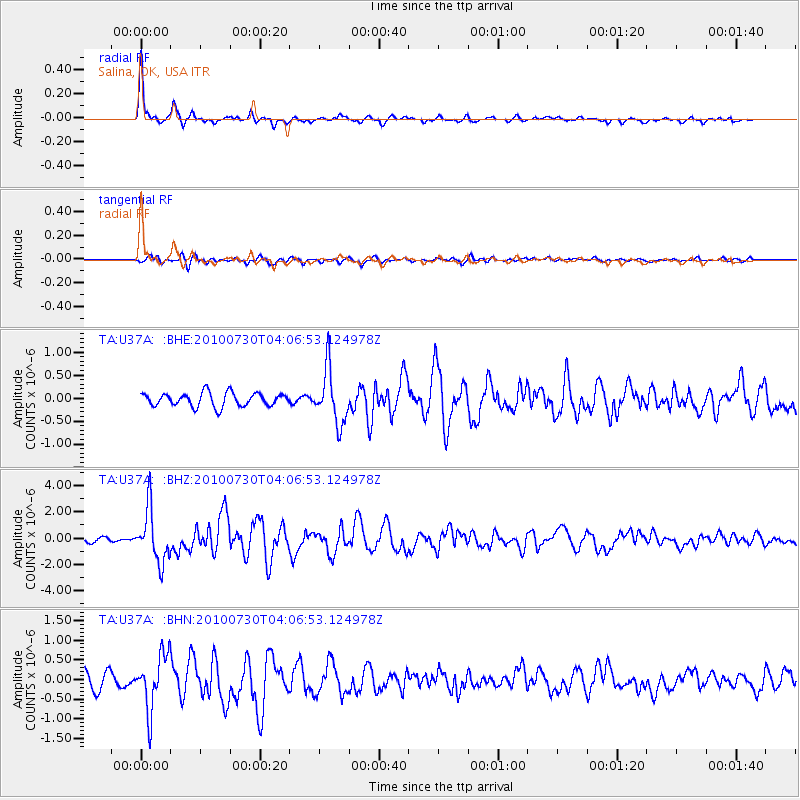
Signal To Noise
| Channel | StoN | STA | LTA |
| TA:U37A: :BHZ:20100730T04:06:53.124978Z | 11.115119 | 2.0087803E-6 | 1.8072502E-7 |
| TA:U37A: :BHN:20100730T04:06:53.124978Z | 4.125877 | 7.047083E-7 | 1.7080208E-7 |
| TA:U37A: :BHE:20100730T04:06:53.124978Z | 3.973828 | 5.894491E-7 | 1.483328E-7 |
| Arrivals |
| Ps | 5.5 SECOND |
| PpPs | 18 SECOND |
| PsPs/PpSs | 24 SECOND |


