You are here: Home > Network List > TA - USArray Transportable Network (new EarthScope stations) Stations List
> Station I31A Royce, Wessington Springs, SD, USA > Earthquake Result Viewer
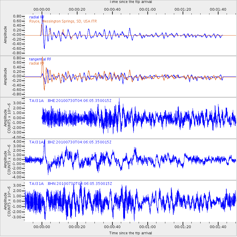
I31A Royce, Wessington Springs, SD, USA - Earthquake Result Viewer

| Earthquake location: |
Off East Coast Of Kamchatka |
| Earthquake latitude/longitude: |
52.5/159.8 |
| Earthquake time(UTC): |
2010/07/30 (211) 03:56:13 GMT |
| Earthquake Depth: |
23 km |
| Earthquake Magnitude: |
6.1 MB, 6.3 MS, 6.3 MW, 6.3 MW |
| Earthquake Catalog/Contributor: |
WHDF/NEIC |
|
| Network: |
TA USArray Transportable Network (new EarthScope stations) |
| Station: |
I31A Royce, Wessington Springs, SD, USA |
| Lat/Lon: |
44.03 N/98.54 W |
| Elevation: |
469 m |
|
| Distance: |
62.7 deg |
| Az: |
52.69 deg |
| Baz: |
317.613 deg |
| Ray Param: |
0.060051385 |
| Estimated Moho Depth: |
37.5 km |
| Estimated Crust Vp/Vs: |
1.81 |
| Assumed Crust Vp: |
6.53 km/s |
| Estimated Crust Vs: |
3.603 km/s |
| Estimated Crust Poisson's Ratio: |
0.28 |
|
| Radial Match: |
92.8602 % |
| Radial Bump: |
400 |
| Transverse Match: |
80.25811 % |
| Transverse Bump: |
400 |
| SOD ConfigId: |
319893 |
| Insert Time: |
2011-01-05 15:01:06.706 +0000 |
| GWidth: |
2.5 |
| Max Bumps: |
400 |
| Tol: |
0.001 |
|
Signal To Noise
| Channel | StoN | STA | LTA |
| TA:I31A: :BHZ:20100730T04:06:05.350015Z | 5.3536506 | 1.767758E-6 | 3.3019674E-7 |
| TA:I31A: :BHN:20100730T04:06:05.350015Z | 1.5284137 | 1.3752892E-6 | 8.998148E-7 |
| TA:I31A: :BHE:20100730T04:06:05.350015Z | 1.2263684 | 1.084587E-6 | 8.843892E-7 |
| Arrivals |
| Ps | 4.9 SECOND |
| PpPs | 15 SECOND |
| PsPs/PpSs | 20 SECOND |


