BVDA2 AZ.BVDA2 - Earthquake Result Viewer
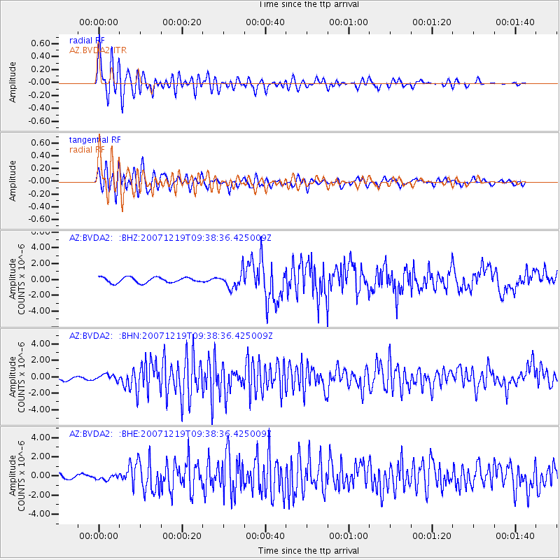
Earthquake location: Andreanof Islands, Aleutian Is.
Earthquake latitude/longitude: 51.4/-179.5
Earthquake time(UTC): 2007/12/19 (353) 09:30:27 GMT
Earthquake Depth: 29 km
Earthquake Magnitude: 6.4 MB, 7.1 MS, 7.1 MW, 7.0 MW
Earthquake Catalog/Contributor: WHDF/NEIC
Network: AZ ANZA Regional Network
Station: BVDA2 AZ.BVDA2
Lat/Lon: 33.33 N/116.37 W
Elevation: 0.0 m
Distance: 48.5 deg
Az: 86.301 deg
Baz: 311.647 deg
Ray Param: 0.06928711
Estimated Moho Depth: 31.0 km
Estimated Crust Vp/Vs: 1.93
Assumed Crust Vp: 6.264 km/s
Estimated Crust Vs: 3.25 km/s
Estimated Crust Poisson's Ratio: 0.32
Radial Match: 88.18464 %
Radial Bump: 400
Transverse Match: 87.31802 %
Transverse Bump: 400
SOD ConfigId: 2564
Insert Time: 2010-02-26 18:38:50.178 +0000
GWidth: 2.5
Max Bumps: 400
Tol: 0.001

Signal To Noise

ChannelStoNSTALTA
AZ:BVDA2: :BHN:20071219T09:38:36.425009Z1.27383773.75866E-72.9506583E-7
AZ:BVDA2: :BHE:20071219T09:38:36.425009Z1.30437792.6275566E-72.0144138E-7
AZ:BVDA2: :BHZ:20071219T09:38:36.425009Z3.0450081.0368128E-63.4049594E-7
Arrivals
Ps4.8 SECOND
PpPs14 SECOND
PsPs/PpSs19 SECOND