You are here: Home > Network List > AZ - ANZA Regional Network Stations List
> Station BVDA2 AZ.BVDA2 > Earthquake Result Viewer
BVDA2 AZ.BVDA2 - Earthquake Result Viewer

| Earthquake location: |
Windward Islands |
| Earthquake latitude/longitude: |
15.0/-61.3 |
| Earthquake time(UTC): |
2007/11/29 (333) 19:00:19 GMT |
| Earthquake Depth: |
148 km |
| Earthquake Magnitude: |
6.9 MB, 7.4 MW, 7.4 MW |
| Earthquake Catalog/Contributor: |
WHDF/NEIC |
|
| Network: |
AZ ANZA Regional Network |
| Station: |
BVDA2 AZ.BVDA2 |
| Lat/Lon: |
33.33 N/116.37 W |
| Elevation: |
0.0 m |
|
| Distance: |
52.9 deg |
| Az: |
300.564 deg |
| Baz: |
96.292 deg |
| Ray Param: |
0.06595792 |
| Estimated Moho Depth: |
19.5 km |
| Estimated Crust Vp/Vs: |
2.03 |
| Assumed Crust Vp: |
6.264 km/s |
| Estimated Crust Vs: |
3.089 km/s |
| Estimated Crust Poisson's Ratio: |
0.34 |
|
| Radial Match: |
86.81953 % |
| Radial Bump: |
400 |
| Transverse Match: |
77.07642 % |
| Transverse Bump: |
400 |
| SOD ConfigId: |
2564 |
| Insert Time: |
2010-02-26 18:38:51.040 +0000 |
| GWidth: |
2.5 |
| Max Bumps: |
400 |
| Tol: |
0.001 |
|
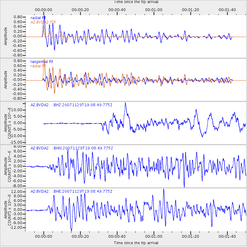
Signal To Noise
| Channel | StoN | STA | LTA |
| AZ:BVDA2: :BHN:20071129T19:08:49.775Z | 3.2522204 | 4.5709325E-7 | 1.4054805E-7 |
| AZ:BVDA2: :BHE:20071129T19:08:49.775Z | 11.546291 | 1.2035421E-6 | 1.0423626E-7 |
| AZ:BVDA2: :BHZ:20071129T19:08:49.775Z | 15.45411 | 2.1850065E-6 | 1.4138675E-7 |
| Arrivals |
| Ps | 3.3 SECOND |
| PpPs | 9.0 SECOND |
| PsPs/PpSs | 12 SECOND |


