You are here: Home > Network List > IW - Intermountain West Stations List
> Station MOOW Moose Ponds, Wyoming, USA > Earthquake Result Viewer
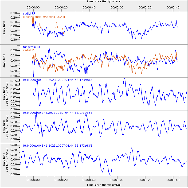
MOOW Moose Ponds, Wyoming, USA - Earthquake Result Viewer
*The percent match for this event was below the threshold and hence no stack was calculated.
| Earthquake location: |
Vanuatu Islands |
| Earthquake latitude/longitude: |
-19.4/168.8 |
| Earthquake time(UTC): |
2023/10/29 (302) 04:32:08 GMT |
| Earthquake Depth: |
80 km |
| Earthquake Magnitude: |
6.0 mww |
| Earthquake Catalog/Contributor: |
NEIC PDE/us |
|
| Network: |
IW Intermountain West |
| Station: |
MOOW Moose Ponds, Wyoming, USA |
| Lat/Lon: |
43.75 N/110.74 W |
| Elevation: |
2128 m |
|
| Distance: |
96.6 deg |
| Az: |
46.011 deg |
| Baz: |
249.557 deg |
| Ray Param: |
$rayparam |
*The percent match for this event was below the threshold and hence was not used in the summary stack. |
|
| Radial Match: |
41.026783 % |
| Radial Bump: |
400 |
| Transverse Match: |
53.170116 % |
| Transverse Bump: |
400 |
| SOD ConfigId: |
31937991 |
| Insert Time: |
2023-11-12 04:48:19.820 +0000 |
| GWidth: |
2.5 |
| Max Bumps: |
400 |
| Tol: |
0.001 |
|
Signal To Noise
| Channel | StoN | STA | LTA |
| IW:MOOW:00:BHZ:20231029T04:44:58.173986Z | 1.8149978 | 1.3873544E-7 | 7.6438354E-8 |
| IW:MOOW:00:BH1:20231029T04:44:58.173986Z | 1.1292906 | 8.2750695E-8 | 7.327671E-8 |
| IW:MOOW:00:BH2:20231029T04:44:58.173986Z | 0.5778794 | 4.697263E-8 | 8.1284476E-8 |
| Arrivals |
| Ps | |
| PpPs | |
| PsPs/PpSs | |


