You are here: Home > Network List > US - United States National Seismic Network Stations List
> Station SDCO Great Sand Dunes National Park, Colorado, USA > Earthquake Result Viewer
SDCO Great Sand Dunes National Park, Colorado, USA - Earthquake Result Viewer
| Earthquake location: |
Off East Coast Of Kamchatka |
| Earthquake latitude/longitude: |
52.5/159.8 |
| Earthquake time(UTC): |
2010/07/30 (211) 03:56:13 GMT |
| Earthquake Depth: |
23 km |
| Earthquake Magnitude: |
6.1 MB, 6.3 MS, 6.3 MW, 6.3 MW |
| Earthquake Catalog/Contributor: |
WHDF/NEIC |
|
| Network: |
US United States National Seismic Network |
| Station: |
SDCO Great Sand Dunes National Park, Colorado, USA |
| Lat/Lon: |
37.75 N/105.50 W |
| Elevation: |
2569 m |
|
| Distance: |
63.7 deg |
| Az: |
61.803 deg |
| Baz: |
317.18 deg |
| Ray Param: |
0.059377223 |
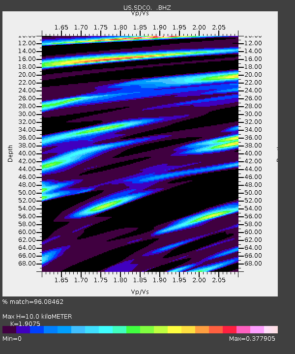
| Estimated Moho Depth: |
10.0 km |
| Estimated Crust Vp/Vs: |
1.91 |
| Assumed Crust Vp: |
6.316 km/s |
| Estimated Crust Vs: |
3.311 km/s |
| Estimated Crust Poisson's Ratio: |
0.31 |
|
| Radial Match: |
96.08462 % |
| Radial Bump: |
264 |
| Transverse Match: |
90.029205 % |
| Transverse Bump: |
329 |
| SOD ConfigId: |
319893 |
| Insert Time: |
2011-01-05 15:04:14.844 +0000 |
| GWidth: |
2.5 |
| Max Bumps: |
400 |
| Tol: |
0.001 |
|

Signal To Noise
| Channel | StoN | STA | LTA |
| US:SDCO: :BHZ:20100730T04:06:12.225015Z | 17.534956 | 1.3845564E-6 | 7.8959786E-8 |
| US:SDCO: :BHN:20100730T04:06:12.225015Z | 7.1490316 | 2.3722706E-7 | 3.3183102E-8 |
| US:SDCO: :BHE:20100730T04:06:12.225015Z | 10.697817 | 5.910274E-7 | 5.524748E-8 |
| Arrivals |
| Ps | 1.5 SECOND |
| PpPs | 4.4 SECOND |
| PsPs/PpSs | 5.9 SECOND |


