You are here: Home > Network List > PS - Pacific21 Stations List
> Station PSI Parapat, Indonesia > Earthquake Result Viewer
PSI Parapat, Indonesia - Earthquake Result Viewer
| Earthquake location: |
Vanuatu Islands |
| Earthquake latitude/longitude: |
-19.4/168.8 |
| Earthquake time(UTC): |
2023/10/29 (302) 04:32:08 GMT |
| Earthquake Depth: |
80 km |
| Earthquake Magnitude: |
6.0 mww |
| Earthquake Catalog/Contributor: |
NEIC PDE/us |
|
| Network: |
PS Pacific21 |
| Station: |
PSI Parapat, Indonesia |
| Lat/Lon: |
2.69 N/98.92 E |
| Elevation: |
987 m |
|
| Distance: |
72.0 deg |
| Az: |
279.551 deg |
| Baz: |
111.288 deg |
| Ray Param: |
0.053786874 |
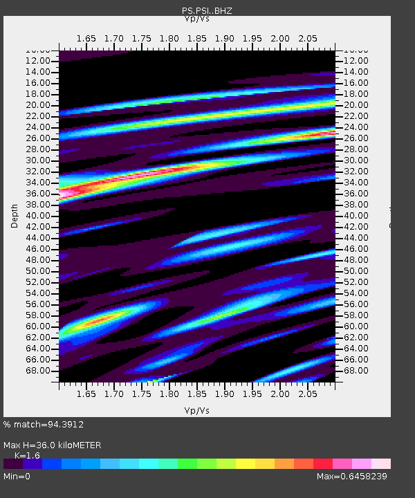
| Estimated Moho Depth: |
36.0 km |
| Estimated Crust Vp/Vs: |
1.60 |
| Assumed Crust Vp: |
6.468 km/s |
| Estimated Crust Vs: |
4.042 km/s |
| Estimated Crust Poisson's Ratio: |
0.18 |
|
| Radial Match: |
94.3912 % |
| Radial Bump: |
400 |
| Transverse Match: |
86.01274 % |
| Transverse Bump: |
400 |
| SOD ConfigId: |
31937991 |
| Insert Time: |
2023-11-12 04:50:41.114 +0000 |
| GWidth: |
2.5 |
| Max Bumps: |
400 |
| Tol: |
0.001 |
|
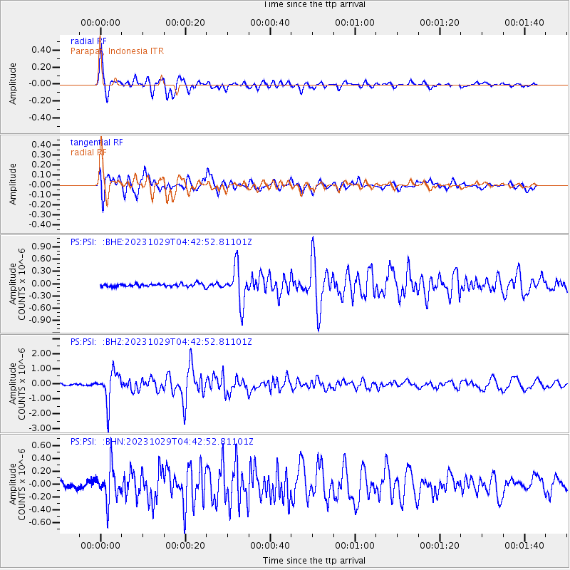
Signal To Noise
| Channel | StoN | STA | LTA |
| PS:PSI: :BHZ:20231029T04:42:52.81101Z | 19.9646 | 1.0304101E-6 | 5.161186E-8 |
| PS:PSI: :BHN:20231029T04:42:52.81101Z | 3.6548812 | 2.6783292E-7 | 7.328088E-8 |
| PS:PSI: :BHE:20231029T04:42:52.81101Z | 12.971011 | 4.49029E-7 | 3.4617887E-8 |
| Arrivals |
| Ps | 3.5 SECOND |
| PpPs | 14 SECOND |
| PsPs/PpSs | 17 SECOND |


