You are here: Home > Network List > US - United States National Seismic Network Stations List
> Station TZTN Tazewell, Tennessee, USA > Earthquake Result Viewer
TZTN Tazewell, Tennessee, USA - Earthquake Result Viewer
| Earthquake location: |
Off East Coast Of Kamchatka |
| Earthquake latitude/longitude: |
52.5/159.8 |
| Earthquake time(UTC): |
2010/07/30 (211) 03:56:13 GMT |
| Earthquake Depth: |
23 km |
| Earthquake Magnitude: |
6.1 MB, 6.3 MS, 6.3 MW, 6.3 MW |
| Earthquake Catalog/Contributor: |
WHDF/NEIC |
|
| Network: |
US United States National Seismic Network |
| Station: |
TZTN Tazewell, Tennessee, USA |
| Lat/Lon: |
36.54 N/83.55 W |
| Elevation: |
394 m |
|
| Distance: |
75.6 deg |
| Az: |
48.019 deg |
| Baz: |
325.644 deg |
| Ray Param: |
0.051532365 |
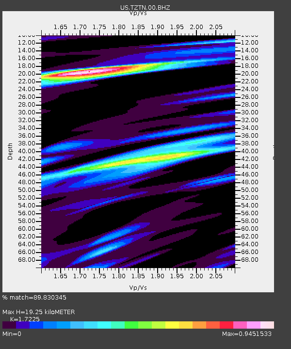
| Estimated Moho Depth: |
19.25 km |
| Estimated Crust Vp/Vs: |
1.72 |
| Assumed Crust Vp: |
6.476 km/s |
| Estimated Crust Vs: |
3.76 km/s |
| Estimated Crust Poisson's Ratio: |
0.25 |
|
| Radial Match: |
89.830345 % |
| Radial Bump: |
400 |
| Transverse Match: |
85.29937 % |
| Transverse Bump: |
400 |
| SOD ConfigId: |
319893 |
| Insert Time: |
2011-01-05 15:04:37.440 +0000 |
| GWidth: |
2.5 |
| Max Bumps: |
400 |
| Tol: |
0.001 |
|

Signal To Noise
| Channel | StoN | STA | LTA |
| US:TZTN:00:BHZ:20100730T04:07:25.389993Z | 9.642475 | 2.6767884E-6 | 2.7760387E-7 |
| US:TZTN:00:BHN:20100730T04:07:25.389993Z | 4.1443815 | 8.433069E-7 | 2.0348196E-7 |
| US:TZTN:00:BHE:20100730T04:07:25.389993Z | 3.9329033 | 6.234104E-7 | 1.5851151E-7 |
| Arrivals |
| Ps | 2.2 SECOND |
| PpPs | 7.8 SECOND |
| PsPs/PpSs | 10 SECOND |


