You are here: Home > Network List > AZ - ANZA Regional Network Stations List
> Station BVDA2 AZ.BVDA2 > Earthquake Result Viewer
BVDA2 AZ.BVDA2 - Earthquake Result Viewer

| Earthquake location: |
Santa Cruz Islands |
| Earthquake latitude/longitude: |
-11.6/165.8 |
| Earthquake time(UTC): |
2007/09/02 (245) 01:05:18 GMT |
| Earthquake Depth: |
35 km |
| Earthquake Magnitude: |
5.9 MB, 7.3 MS, 7.2 MW, 6.9 ME |
| Earthquake Catalog/Contributor: |
WHDF/NEIC |
|
| Network: |
AZ ANZA Regional Network |
| Station: |
BVDA2 AZ.BVDA2 |
| Lat/Lon: |
33.33 N/116.37 W |
| Elevation: |
0.0 m |
|
| Distance: |
86.4 deg |
| Az: |
55.103 deg |
| Baz: |
253.708 deg |
| Ray Param: |
0.04404171 |
| Estimated Moho Depth: |
26.0 km |
| Estimated Crust Vp/Vs: |
1.71 |
| Assumed Crust Vp: |
6.264 km/s |
| Estimated Crust Vs: |
3.668 km/s |
| Estimated Crust Poisson's Ratio: |
0.24 |
|
| Radial Match: |
93.58761 % |
| Radial Bump: |
400 |
| Transverse Match: |
73.50538 % |
| Transverse Bump: |
400 |
| SOD ConfigId: |
2564 |
| Insert Time: |
2010-02-26 18:38:56.418 +0000 |
| GWidth: |
2.5 |
| Max Bumps: |
400 |
| Tol: |
0.001 |
|
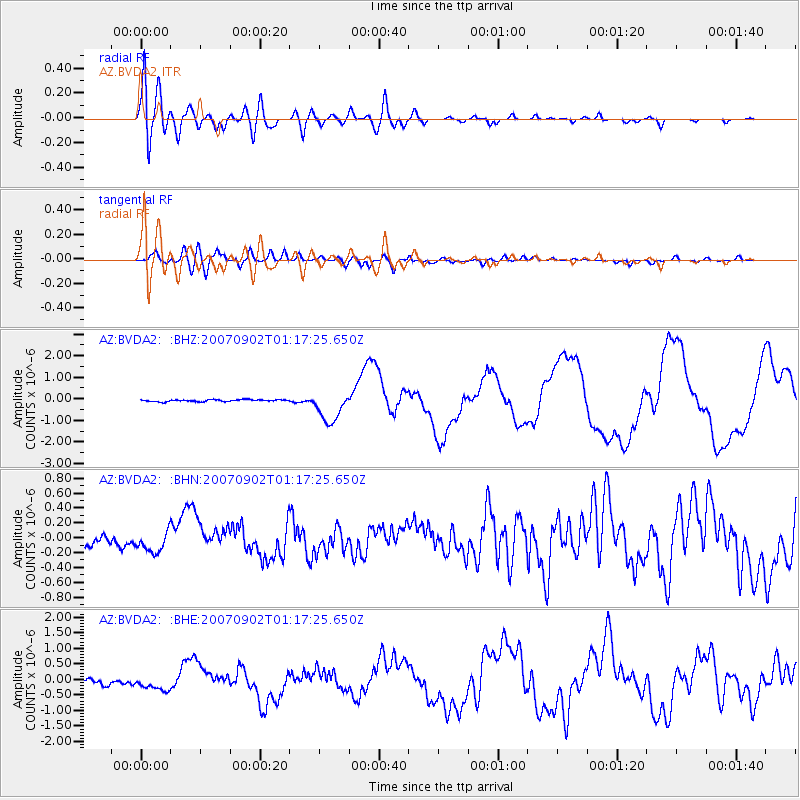
Signal To Noise
| Channel | StoN | STA | LTA |
| AZ:BVDA2: :BHN:20070902T01:17:25.650Z | 2.1797247 | 1.3549582E-7 | 6.21619E-8 |
| AZ:BVDA2: :BHE:20070902T01:17:25.650Z | 2.361647 | 2.3177434E-7 | 9.814097E-8 |
| AZ:BVDA2: :BHZ:20070902T01:17:25.650Z | 16.651613 | 7.2460966E-7 | 4.3515886E-8 |
| Arrivals |
| Ps | 3.0 SECOND |
| PpPs | 11 SECOND |
| PsPs/PpSs | 14 SECOND |


