You are here: Home > Network List > US - United States National Seismic Network Stations List
> Station PKME Peaks-Kenny State Park, Maine, USA > Earthquake Result Viewer
PKME Peaks-Kenny State Park, Maine, USA - Earthquake Result Viewer
| Earthquake location: |
Off East Coast Of Kamchatka |
| Earthquake latitude/longitude: |
52.5/159.8 |
| Earthquake time(UTC): |
2010/07/30 (211) 03:56:13 GMT |
| Earthquake Depth: |
23 km |
| Earthquake Magnitude: |
6.1 MB, 6.3 MS, 6.3 MW, 6.3 MW |
| Earthquake Catalog/Contributor: |
WHDF/NEIC |
|
| Network: |
US United States National Seismic Network |
| Station: |
PKME Peaks-Kenny State Park, Maine, USA |
| Lat/Lon: |
45.26 N/69.29 W |
| Elevation: |
108 m |
|
| Distance: |
73.9 deg |
| Az: |
33.777 deg |
| Baz: |
331.231 deg |
| Ray Param: |
0.052687813 |
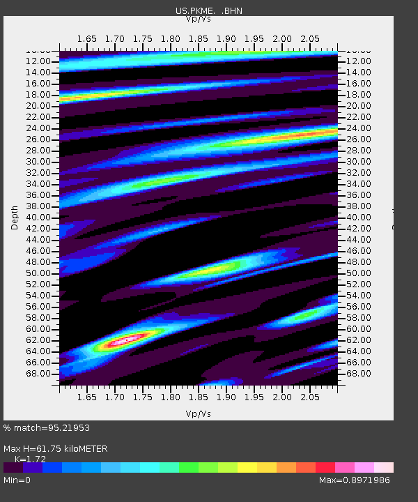
| Estimated Moho Depth: |
61.75 km |
| Estimated Crust Vp/Vs: |
1.72 |
| Assumed Crust Vp: |
6.419 km/s |
| Estimated Crust Vs: |
3.732 km/s |
| Estimated Crust Poisson's Ratio: |
0.24 |
|
| Radial Match: |
95.21953 % |
| Radial Bump: |
326 |
| Transverse Match: |
96.13023 % |
| Transverse Bump: |
305 |
| SOD ConfigId: |
319893 |
| Insert Time: |
2011-01-05 15:05:04.606 +0000 |
| GWidth: |
2.5 |
| Max Bumps: |
400 |
| Tol: |
0.001 |
|

Signal To Noise
| Channel | StoN | STA | LTA |
| US:PKME: :BHZ:20100730T04:07:15.400002Z | 12.314124 | 2.2089266E-6 | 1.7938154E-7 |
| US:PKME: :BHN:20100730T04:07:15.400002Z | 13.094317 | 1.7823909E-6 | 1.3611943E-7 |
| US:PKME: :BHE:20100730T04:07:15.400002Z | 1.0612109 | 1.5321233E-7 | 1.4437501E-7 |
| Arrivals |
| Ps | 7.2 SECOND |
| PpPs | 25 SECOND |
| PsPs/PpSs | 32 SECOND |


