You are here: Home > Network List > US - United States National Seismic Network Stations List
> Station OGNE Ogallala, Nebraska, USA > Earthquake Result Viewer
OGNE Ogallala, Nebraska, USA - Earthquake Result Viewer
| Earthquake location: |
Off East Coast Of Kamchatka |
| Earthquake latitude/longitude: |
52.5/159.8 |
| Earthquake time(UTC): |
2010/07/30 (211) 03:56:13 GMT |
| Earthquake Depth: |
23 km |
| Earthquake Magnitude: |
6.1 MB, 6.3 MS, 6.3 MW, 6.3 MW |
| Earthquake Catalog/Contributor: |
WHDF/NEIC |
|
| Network: |
US United States National Seismic Network |
| Station: |
OGNE Ogallala, Nebraska, USA |
| Lat/Lon: |
40.95 N/102.03 W |
| Elevation: |
0.0 m |
|
| Distance: |
63.2 deg |
| Az: |
57.171 deg |
| Baz: |
317.299 deg |
| Ray Param: |
0.059714086 |
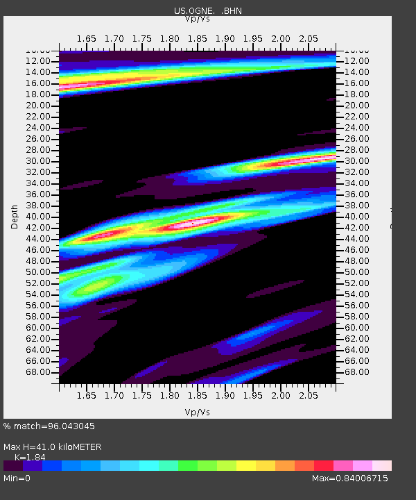
| Estimated Moho Depth: |
41.0 km |
| Estimated Crust Vp/Vs: |
1.84 |
| Assumed Crust Vp: |
6.483 km/s |
| Estimated Crust Vs: |
3.523 km/s |
| Estimated Crust Poisson's Ratio: |
0.29 |
|
| Radial Match: |
96.043045 % |
| Radial Bump: |
319 |
| Transverse Match: |
68.48111 % |
| Transverse Bump: |
356 |
| SOD ConfigId: |
319893 |
| Insert Time: |
2011-01-05 15:06:03.898 +0000 |
| GWidth: |
2.5 |
| Max Bumps: |
400 |
| Tol: |
0.001 |
|

Signal To Noise
| Channel | StoN | STA | LTA |
| US:OGNE: :BHZ:20100730T04:06:08.800027Z | 27.128454 | 3.3241895E-6 | 1.2253516E-7 |
| US:OGNE: :BHN:20100730T04:06:08.800027Z | 3.140598 | 1.1846571E-6 | 3.772075E-7 |
| US:OGNE: :BHE:20100730T04:06:08.800027Z | 2.9112146 | 1.073834E-6 | 3.6886118E-7 |
| Arrivals |
| Ps | 5.5 SECOND |
| PpPs | 17 SECOND |
| PsPs/PpSs | 23 SECOND |


