You are here: Home > Network List > UW - Pacific Northwest Regional Seismic Network Stations List
> Station TAKO Tahkenitch, OR CREST BB SMO > Earthquake Result Viewer
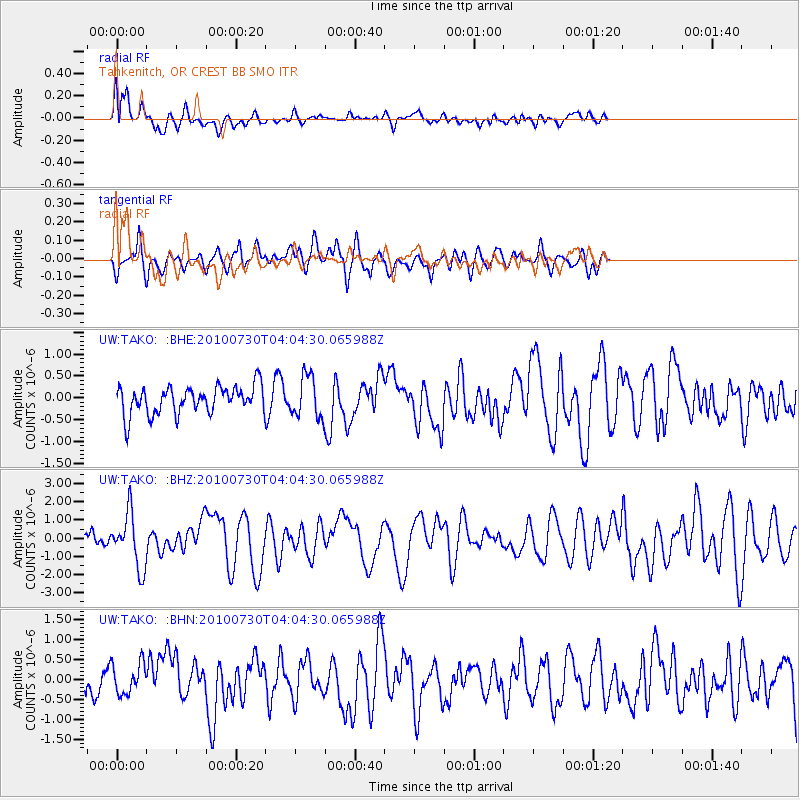
TAKO Tahkenitch, OR CREST BB SMO - Earthquake Result Viewer
*The percent match for this event was below the threshold and hence no stack was calculated.
| Earthquake location: |
Off East Coast Of Kamchatka |
| Earthquake latitude/longitude: |
52.5/159.8 |
| Earthquake time(UTC): |
2010/07/30 (211) 03:56:13 GMT |
| Earthquake Depth: |
23 km |
| Earthquake Magnitude: |
6.1 MB, 6.3 MS, 6.3 MW, 6.3 MW |
| Earthquake Catalog/Contributor: |
WHDF/NEIC |
|
| Network: |
UW Pacific Northwest Regional Seismic Network |
| Station: |
TAKO Tahkenitch, OR CREST BB SMO |
| Lat/Lon: |
43.74 N/124.08 W |
| Elevation: |
46 m |
|
| Distance: |
49.3 deg |
| Az: |
68.071 deg |
| Baz: |
308.509 deg |
| Ray Param: |
$rayparam |
*The percent match for this event was below the threshold and hence was not used in the summary stack. |
|
| Radial Match: |
76.78476 % |
| Radial Bump: |
400 |
| Transverse Match: |
51.208736 % |
| Transverse Bump: |
400 |
| SOD ConfigId: |
319893 |
| Insert Time: |
2011-01-05 15:06:10.995 +0000 |
| GWidth: |
2.5 |
| Max Bumps: |
400 |
| Tol: |
0.001 |
|
Signal To Noise
| Channel | StoN | STA | LTA |
| UW:TAKO: :BHZ:20100730T04:04:30.065988Z | 4.7311883 | 1.4817296E-6 | 3.1318336E-7 |
| UW:TAKO: :BHN:20100730T04:04:30.065988Z | 1.0978056 | 3.8904767E-7 | 3.5438669E-7 |
| UW:TAKO: :BHE:20100730T04:04:30.065988Z | 1.5151656 | 4.7675013E-7 | 3.1465217E-7 |
| Arrivals |
| Ps | |
| PpPs | |
| PsPs/PpSs | |


