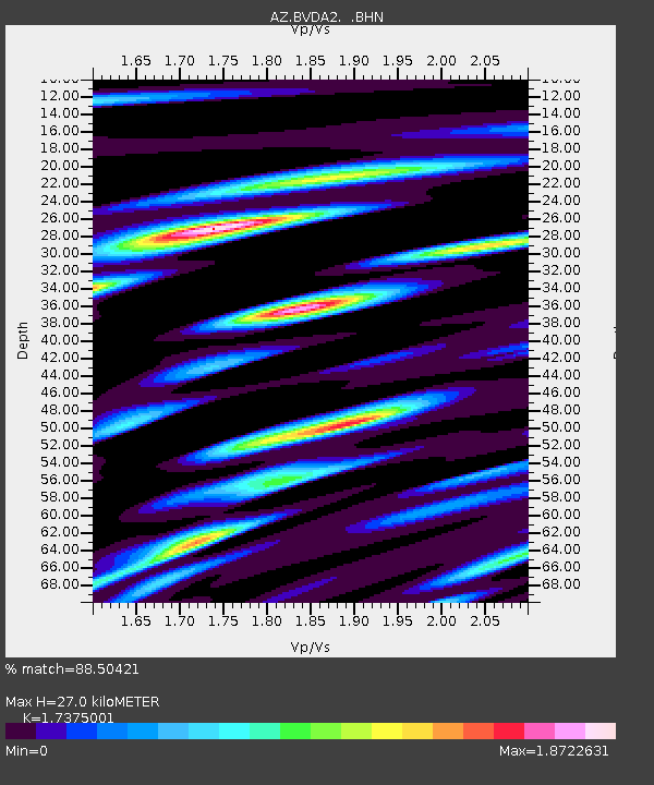
BVDA2 AZ.BVDA2 - Earthquake Result Viewer
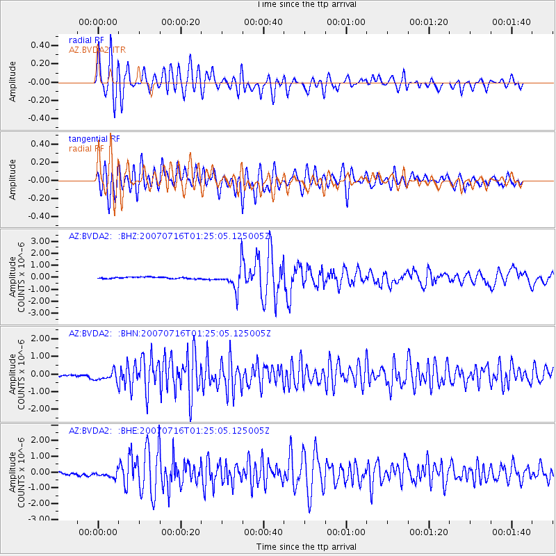
Earthquake location: Near West Coast Of Honshu, Japan
Earthquake latitude/longitude: 37.5/138.4
Earthquake time(UTC): 2007/07/16 (197) 01:13:22 GMT
Earthquake Depth: 12 km
Earthquake Magnitude: 6.5 MB, 6.4 MS, 6.6 MW, 6.5 MW
Earthquake Catalog/Contributor: WHDF/NEIC
Network: AZ ANZA Regional Network
Station: BVDA2 AZ.BVDA2
Lat/Lon: 33.33 N/116.37 W
Elevation: 0.0 m
Distance: 80.9 deg
Az: 54.904 deg
Baz: 309.026 deg
Ray Param: 0.047928866
Estimated Moho Depth: 27.0 km
Estimated Crust Vp/Vs: 1.74
Assumed Crust Vp: 6.264 km/s
Estimated Crust Vs: 3.605 km/s
Estimated Crust Poisson's Ratio: 0.25
Radial Match: 88.50421 %
Radial Bump: 400
Transverse Match: 81.64196 %
Transverse Bump: 400
SOD ConfigId: 2564
Insert Time: 2010-02-26 18:39:01.530 +0000
GWidth: 2.5
Max Bumps: 400
Tol: 0.001

Signal To Noise

ChannelStoNSTALTA
AZ:BVDA2: :BHN:20070716T01:25:05.125005Z3.3224662.963452E-78.919436E-8
AZ:BVDA2: :BHE:20070716T01:25:05.125005Z3.82567242.2743485E-75.9449643E-8
AZ:BVDA2: :BHZ:20070716T01:25:05.125005Z16.2163811.0626164E-66.552735E-8
Arrivals
Ps3.3 SECOND
PpPs11 SECOND
PsPs/PpSs15 SECOND