You are here: Home > Network List > AZ - ANZA Regional Network Stations List
> Station BVDA2 AZ.BVDA2 > Earthquake Result Viewer
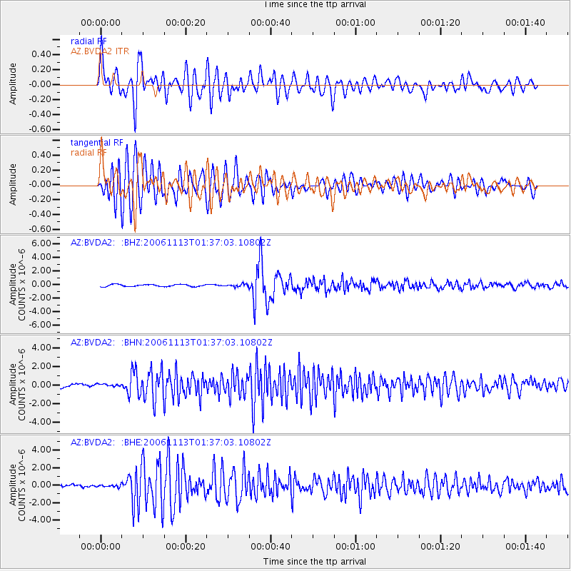
BVDA2 AZ.BVDA2 - Earthquake Result Viewer

| Earthquake location: |
Santiago Del Estero Prov., Arg. |
| Earthquake latitude/longitude: |
-26.0/-63.2 |
| Earthquake time(UTC): |
2006/11/13 (317) 01:26:34 GMT |
| Earthquake Depth: |
552 km |
| Earthquake Magnitude: |
6.3 MB, 6.8 MW, 6.8 MW |
| Earthquake Catalog/Contributor: |
WHDF/NEIC |
|
| Network: |
AZ ANZA Regional Network |
| Station: |
BVDA2 AZ.BVDA2 |
| Lat/Lon: |
33.33 N/116.37 W |
| Elevation: |
0.0 m |
|
| Distance: |
77.7 deg |
| Az: |
316.713 deg |
| Baz: |
132.544 deg |
| Ray Param: |
0.048433352 |
| Estimated Moho Depth: |
59.75 km |
| Estimated Crust Vp/Vs: |
1.94 |
| Assumed Crust Vp: |
6.264 km/s |
| Estimated Crust Vs: |
3.225 km/s |
| Estimated Crust Poisson's Ratio: |
0.32 |
|
| Radial Match: |
81.74221 % |
| Radial Bump: |
400 |
| Transverse Match: |
81.19583 % |
| Transverse Bump: |
400 |
| SOD ConfigId: |
2564 |
| Insert Time: |
2010-02-26 18:39:06.074 +0000 |
| GWidth: |
2.5 |
| Max Bumps: |
400 |
| Tol: |
0.001 |
|
Signal To Noise
| Channel | StoN | STA | LTA |
| AZ:BVDA2: :BHN:20061113T01:37:03.10802Z | 0.9610938 | 1.3680605E-7 | 1.4234412E-7 |
| AZ:BVDA2: :BHE:20061113T01:37:03.10802Z | 0.9847813 | 1.2921915E-7 | 1.3121607E-7 |
| AZ:BVDA2: :BHZ:20061113T01:37:03.10802Z | 1.2515769 | 1.8869544E-7 | 1.5076616E-7 |
| Arrivals |
| Ps | 9.2 SECOND |
| PpPs | 27 SECOND |
| PsPs/PpSs | 37 SECOND |


