You are here: Home > Network List > TA - USArray Transportable Network (new EarthScope stations) Stations List
> Station E23A Ismay, MT, USA > Earthquake Result Viewer
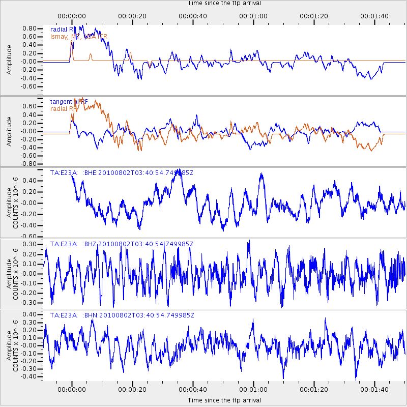
E23A Ismay, MT, USA - Earthquake Result Viewer
*The percent match for this event was below the threshold and hence no stack was calculated.
| Earthquake location: |
Central Mid-Atlantic Ridge |
| Earthquake latitude/longitude: |
7.1/-34.2 |
| Earthquake time(UTC): |
2010/08/02 (214) 03:30:02 GMT |
| Earthquake Depth: |
10 km |
| Earthquake Magnitude: |
5.8 MW, 4.9 MS, 4.9 MB, 5.6 MW |
| Earthquake Catalog/Contributor: |
WHDF/NEIC |
|
| Network: |
TA USArray Transportable Network (new EarthScope stations) |
| Station: |
E23A Ismay, MT, USA |
| Lat/Lon: |
46.50 N/105.31 W |
| Elevation: |
750 m |
|
| Distance: |
71.9 deg |
| Az: |
316.556 deg |
| Baz: |
98.932 deg |
| Ray Param: |
$rayparam |
*The percent match for this event was below the threshold and hence was not used in the summary stack. |
|
| Radial Match: |
55.553497 % |
| Radial Bump: |
400 |
| Transverse Match: |
41.16772 % |
| Transverse Bump: |
400 |
| SOD ConfigId: |
319893 |
| Insert Time: |
2011-01-05 15:16:25.776 +0000 |
| GWidth: |
2.5 |
| Max Bumps: |
400 |
| Tol: |
0.001 |
|
Signal To Noise
| Channel | StoN | STA | LTA |
| TA:E23A: :BHZ:20100802T03:40:54.749985Z | 1.2455937 | 1.2715759E-7 | 1.02085934E-7 |
| TA:E23A: :BHN:20100802T03:40:54.749985Z | 0.9020535 | 1.5560168E-7 | 1.7249718E-7 |
| TA:E23A: :BHE:20100802T03:40:54.749985Z | 1.8556702 | 3.8176347E-7 | 2.0572807E-7 |
| Arrivals |
| Ps | |
| PpPs | |
| PsPs/PpSs | |


