You are here: Home > Network List > TA - USArray Transportable Network (new EarthScope stations) Stations List
> Station I03D Drain, OR, USA > Earthquake Result Viewer
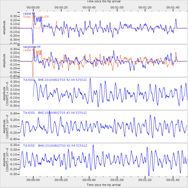
I03D Drain, OR, USA - Earthquake Result Viewer
*The percent match for this event was below the threshold and hence no stack was calculated.
| Earthquake location: |
Central Mid-Atlantic Ridge |
| Earthquake latitude/longitude: |
7.1/-34.2 |
| Earthquake time(UTC): |
2010/08/02 (214) 03:30:02 GMT |
| Earthquake Depth: |
10 km |
| Earthquake Magnitude: |
5.8 MW, 4.9 MS, 4.9 MB, 5.6 MW |
| Earthquake Catalog/Contributor: |
WHDF/NEIC |
|
| Network: |
TA USArray Transportable Network (new EarthScope stations) |
| Station: |
I03D Drain, OR, USA |
| Lat/Lon: |
43.70 N/123.35 W |
| Elevation: |
140 m |
|
| Distance: |
84.5 deg |
| Az: |
313.235 deg |
| Baz: |
85.455 deg |
| Ray Param: |
$rayparam |
*The percent match for this event was below the threshold and hence was not used in the summary stack. |
|
| Radial Match: |
52.953224 % |
| Radial Bump: |
400 |
| Transverse Match: |
56.41359 % |
| Transverse Bump: |
400 |
| SOD ConfigId: |
319893 |
| Insert Time: |
2011-01-05 15:17:26.177 +0000 |
| GWidth: |
2.5 |
| Max Bumps: |
400 |
| Tol: |
0.001 |
|
Signal To Noise
| Channel | StoN | STA | LTA |
| TA:I03D: :BHZ:20100802T03:42:04.52501Z | 0.9440132 | 1.13281246E-7 | 1.1999964E-7 |
| TA:I03D: :BHN:20100802T03:42:04.52501Z | 0.76076937 | 8.5147136E-8 | 1.11922404E-7 |
| TA:I03D: :BHE:20100802T03:42:04.52501Z | 0.6594904 | 7.805229E-8 | 1.1835242E-7 |
| Arrivals |
| Ps | |
| PpPs | |
| PsPs/PpSs | |


