You are here: Home > Network List > US - United States National Seismic Network Stations List
> Station HAWA Hanford, Washington, USA > Earthquake Result Viewer
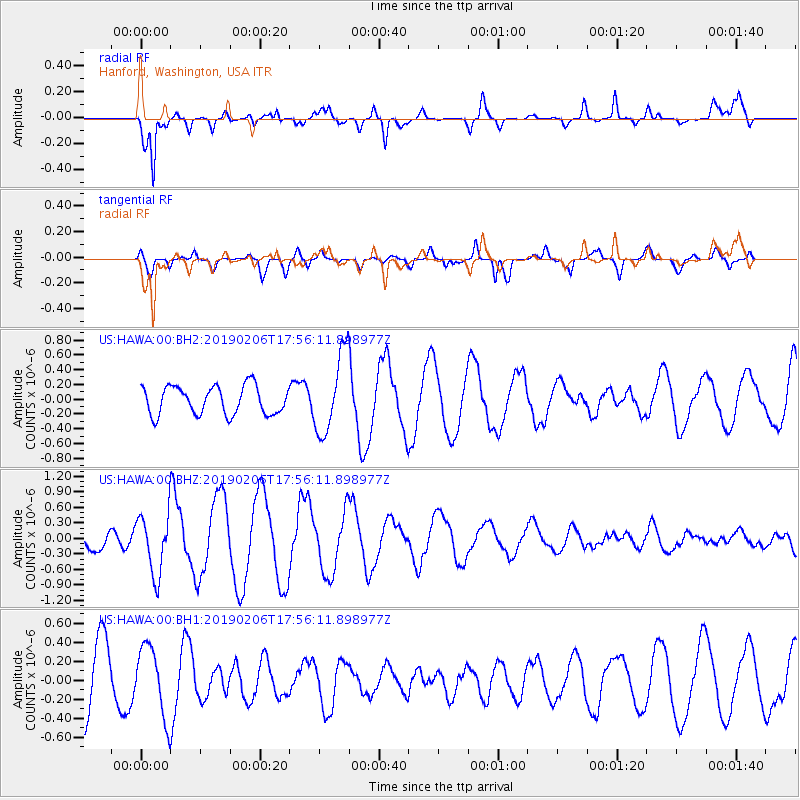
HAWA Hanford, Washington, USA - Earthquake Result Viewer
*The percent match for this event was below the threshold and hence no stack was calculated.
| Earthquake location: |
Mariana Islands Region |
| Earthquake latitude/longitude: |
21.4/146.1 |
| Earthquake time(UTC): |
2019/02/06 (037) 17:44:45 GMT |
| Earthquake Depth: |
4.9 km |
| Earthquake Magnitude: |
5.3 Mww |
| Earthquake Catalog/Contributor: |
NEIC PDE/us |
|
| Network: |
US United States National Seismic Network |
| Station: |
HAWA Hanford, Washington, USA |
| Lat/Lon: |
46.39 N/119.53 W |
| Elevation: |
364 m |
|
| Distance: |
77.7 deg |
| Az: |
44.933 deg |
| Baz: |
288.029 deg |
| Ray Param: |
$rayparam |
*The percent match for this event was below the threshold and hence was not used in the summary stack. |
|
| Radial Match: |
64.97113 % |
| Radial Bump: |
400 |
| Transverse Match: |
55.505585 % |
| Transverse Bump: |
397 |
| SOD ConfigId: |
3287751 |
| Insert Time: |
2019-02-20 17:51:37.851 +0000 |
| GWidth: |
2.5 |
| Max Bumps: |
400 |
| Tol: |
0.001 |
|
Signal To Noise
| Channel | StoN | STA | LTA |
| US:HAWA:00:BHZ:20190206T17:56:11.898977Z | 1.9197633 | 5.714019E-7 | 2.9764186E-7 |
| US:HAWA:00:BH1:20190206T17:56:11.898977Z | 0.92090935 | 3.682256E-7 | 3.9985002E-7 |
| US:HAWA:00:BH2:20190206T17:56:11.898977Z | 2.8040528 | 5.367548E-7 | 1.9142107E-7 |
| Arrivals |
| Ps | |
| PpPs | |
| PsPs/PpSs | |


