You are here: Home > Network List > UW - Pacific Northwest Regional Seismic Network Stations List
> Station UMAT Pilot Rock, OR, USA > Earthquake Result Viewer
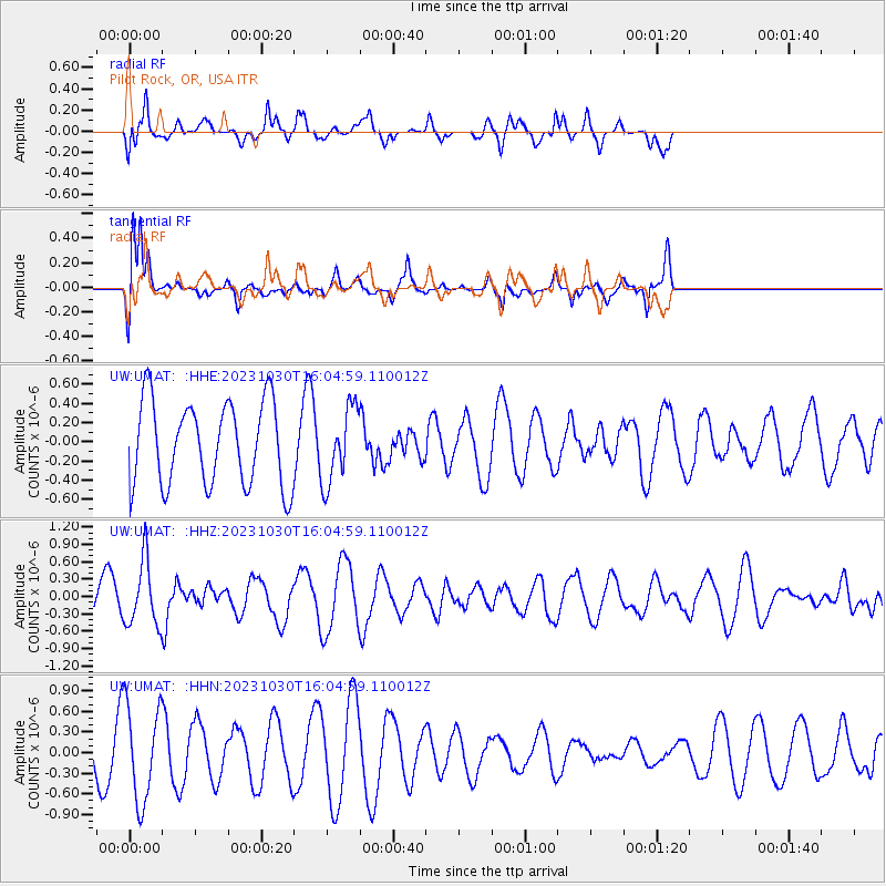
UMAT Pilot Rock, OR, USA - Earthquake Result Viewer
*The percent match for this event was below the threshold and hence no stack was calculated.
| Earthquake location: |
Jamaica Region |
| Earthquake latitude/longitude: |
18.2/-76.6 |
| Earthquake time(UTC): |
2023/10/30 (303) 15:57:20 GMT |
| Earthquake Depth: |
10 km |
| Earthquake Magnitude: |
5.4 mww |
| Earthquake Catalog/Contributor: |
NEIC PDE/us |
|
| Network: |
UW Pacific Northwest Regional Seismic Network |
| Station: |
UMAT Pilot Rock, OR, USA |
| Lat/Lon: |
45.29 N/118.96 W |
| Elevation: |
1318 m |
|
| Distance: |
44.3 deg |
| Az: |
317.071 deg |
| Baz: |
113.489 deg |
| Ray Param: |
$rayparam |
*The percent match for this event was below the threshold and hence was not used in the summary stack. |
|
| Radial Match: |
49.344322 % |
| Radial Bump: |
400 |
| Transverse Match: |
82.79155 % |
| Transverse Bump: |
367 |
| SOD ConfigId: |
31937991 |
| Insert Time: |
2023-11-13 16:19:37.247 +0000 |
| GWidth: |
2.5 |
| Max Bumps: |
400 |
| Tol: |
0.001 |
|
Signal To Noise
| Channel | StoN | STA | LTA |
| UW:UMAT: :HHZ:20231030T16:04:59.110012Z | 2.1062362 | 5.5884976E-7 | 2.65331E-7 |
| UW:UMAT: :HHN:20231030T16:04:59.110012Z | 2.9049625 | 7.0381554E-7 | 2.422804E-7 |
| UW:UMAT: :HHE:20231030T16:04:59.110012Z | 0.8908835 | 3.9022623E-7 | 4.380216E-7 |
| Arrivals |
| Ps | |
| PpPs | |
| PsPs/PpSs | |


