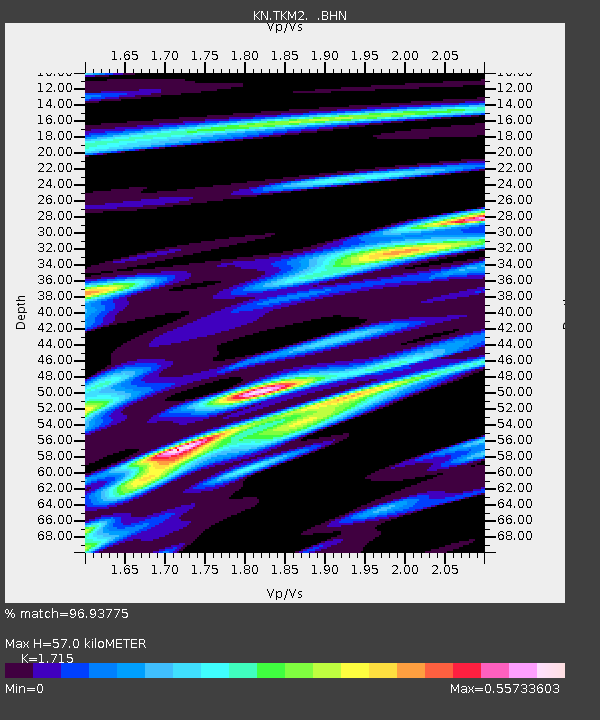
TKM2 KN.TKM2 - Earthquake Result Viewer
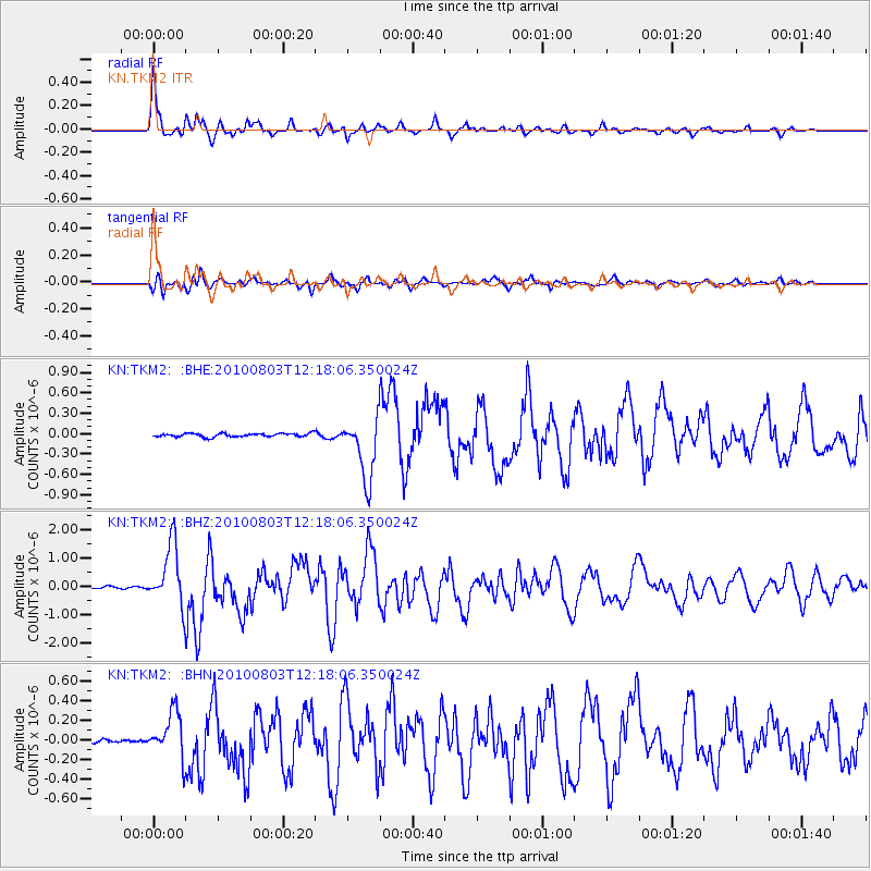
Earthquake location: Northern Molucca Sea
Earthquake latitude/longitude: 1.2/126.2
Earthquake time(UTC): 2010/08/03 (215) 12:08:25 GMT
Earthquake Depth: 41 km
Earthquake Magnitude: 6.1 MB, 5.9 MS, 6.3 MW, 6.3 MW
Earthquake Catalog/Contributor: WHDF/NEIC
Network: KN Kyrgyz Seismic Telemetry Network
Station: TKM2 KN.TKM2
Lat/Lon: 42.92 N/75.60 E
Elevation: 2020 m
Distance: 61.3 deg
Az: 319.653 deg
Baz: 118.218 deg
Ray Param: 0.06089614
Estimated Moho Depth: 57.0 km
Estimated Crust Vp/Vs: 1.72
Assumed Crust Vp: 6.306 km/s
Estimated Crust Vs: 3.677 km/s
Estimated Crust Poisson's Ratio: 0.24
Radial Match: 96.93775 %
Radial Bump: 308
Transverse Match: 83.20059 %
Transverse Bump: 400
SOD ConfigId: 319893
Insert Time: 2011-01-05 15:25:04.514 +0000
GWidth: 2.5
Max Bumps: 400
Tol: 0.001

Signal To Noise

ChannelStoNSTALTA
KN:TKM2: :BHZ:20100803T12:18:06.350024Z37.1932451.0914945E-62.9346579E-8
KN:TKM2: :BHN:20100803T12:18:06.350024Z12.530172.3465837E-71.872747E-8
KN:TKM2: :BHE:20100803T12:18:06.350024Z18.1456074.562944E-72.5146274E-8
Arrivals
Ps6.8 SECOND
PpPs23 SECOND
PsPs/PpSs30 SECOND