You are here: Home > Network List > BK - Berkeley Digital Seismograph Network Stations List
> Station HUMO Hull Mountain, OR > Earthquake Result Viewer
HUMO Hull Mountain, OR - Earthquake Result Viewer
*The percent match for this event was below the threshold and hence no stack was calculated.
| Earthquake location: |
Southeast Of Loyalty Islands |
| Earthquake latitude/longitude: |
-22.6/171.5 |
| Earthquake time(UTC): |
2010/08/03 (215) 22:30:23 GMT |
| Earthquake Depth: |
16 km |
| Earthquake Magnitude: |
5.5 MB, 5.1 MS, 5.6 MW, 5.4 MW |
| Earthquake Catalog/Contributor: |
WHDF/NEIC |
|
| Network: |
BK Berkeley Digital Seismograph Network |
| Station: |
HUMO Hull Mountain, OR |
| Lat/Lon: |
42.61 N/122.96 W |
| Elevation: |
555 m |
|
| Distance: |
88.6 deg |
| Az: |
42.24 deg |
| Baz: |
237.319 deg |
| Ray Param: |
$rayparam |
*The percent match for this event was below the threshold and hence was not used in the summary stack. |
|
| Radial Match: |
72.035416 % |
| Radial Bump: |
400 |
| Transverse Match: |
48.072063 % |
| Transverse Bump: |
400 |
| SOD ConfigId: |
319893 |
| Insert Time: |
2011-01-05 15:28:02.957 +0000 |
| GWidth: |
2.5 |
| Max Bumps: |
400 |
| Tol: |
0.001 |
|
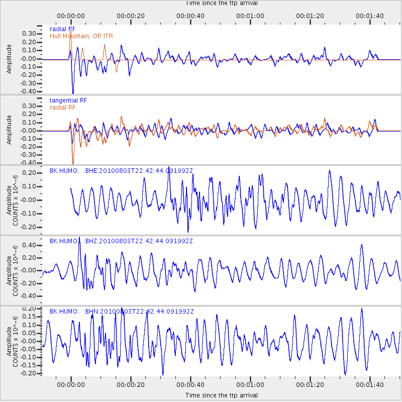
Signal To Noise
| Channel | StoN | STA | LTA |
| BK:HUMO: :BHZ:20100803T22:42:44.091992Z | 2.186782 | 1.9466887E-7 | 8.902071E-8 |
| BK:HUMO: :BHN:20100803T22:42:44.091992Z | 1.0663372 | 7.425683E-8 | 6.963729E-8 |
| BK:HUMO: :BHE:20100803T22:42:44.091992Z | 1.2548646 | 8.605544E-8 | 6.857747E-8 |
| Arrivals |
| Ps | |
| PpPs | |
| PsPs/PpSs | |


