You are here: Home > Network List > CI - Caltech Regional Seismic Network Stations List
> Station SWS Sam W. Stewart, Westmorland, CA, USA > Earthquake Result Viewer
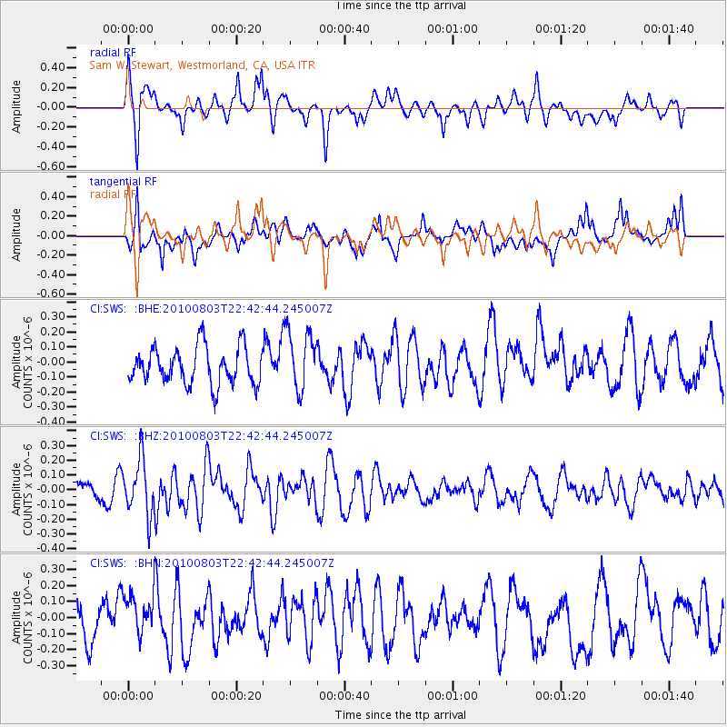
SWS Sam W. Stewart, Westmorland, CA, USA - Earthquake Result Viewer
*The percent match for this event was below the threshold and hence no stack was calculated.
| Earthquake location: |
Southeast Of Loyalty Islands |
| Earthquake latitude/longitude: |
-22.6/171.5 |
| Earthquake time(UTC): |
2010/08/03 (215) 22:30:23 GMT |
| Earthquake Depth: |
16 km |
| Earthquake Magnitude: |
5.5 MB, 5.1 MS, 5.6 MW, 5.4 MW |
| Earthquake Catalog/Contributor: |
WHDF/NEIC |
|
| Network: |
CI Caltech Regional Seismic Network |
| Station: |
SWS Sam W. Stewart, Westmorland, CA, USA |
| Lat/Lon: |
32.94 N/115.80 W |
| Elevation: |
140 m |
|
| Distance: |
88.6 deg |
| Az: |
53.428 deg |
| Baz: |
241.986 deg |
| Ray Param: |
$rayparam |
*The percent match for this event was below the threshold and hence was not used in the summary stack. |
|
| Radial Match: |
62.26298 % |
| Radial Bump: |
383 |
| Transverse Match: |
66.759865 % |
| Transverse Bump: |
400 |
| SOD ConfigId: |
319893 |
| Insert Time: |
2011-01-05 15:29:10.512 +0000 |
| GWidth: |
2.5 |
| Max Bumps: |
400 |
| Tol: |
0.001 |
|
Signal To Noise
| Channel | StoN | STA | LTA |
| CI:SWS: :BHZ:20100803T22:42:44.245007Z | 2.091974 | 1.8644971E-7 | 8.912621E-8 |
| CI:SWS: :BHN:20100803T22:42:44.245007Z | 0.9035276 | 1.3377237E-7 | 1.4805565E-7 |
| CI:SWS: :BHE:20100803T22:42:44.245007Z | 1.6324908 | 2.0034949E-7 | 1.2272626E-7 |
| Arrivals |
| Ps | |
| PpPs | |
| PsPs/PpSs | |


