You are here: Home > Network List > CI - Caltech Regional Seismic Network Stations List
> Station MPM Manuel Prospect Mine, California, USA > Earthquake Result Viewer
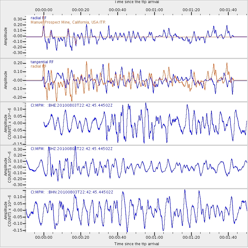
MPM Manuel Prospect Mine, California, USA - Earthquake Result Viewer
*The percent match for this event was below the threshold and hence no stack was calculated.
| Earthquake location: |
Southeast Of Loyalty Islands |
| Earthquake latitude/longitude: |
-22.6/171.5 |
| Earthquake time(UTC): |
2010/08/03 (215) 22:30:23 GMT |
| Earthquake Depth: |
16 km |
| Earthquake Magnitude: |
5.5 MB, 5.1 MS, 5.6 MW, 5.4 MW |
| Earthquake Catalog/Contributor: |
WHDF/NEIC |
|
| Network: |
CI Caltech Regional Seismic Network |
| Station: |
MPM Manuel Prospect Mine, California, USA |
| Lat/Lon: |
36.06 N/117.49 W |
| Elevation: |
185 m |
|
| Distance: |
88.8 deg |
| Az: |
50.027 deg |
| Baz: |
240.955 deg |
| Ray Param: |
$rayparam |
*The percent match for this event was below the threshold and hence was not used in the summary stack. |
|
| Radial Match: |
71.59556 % |
| Radial Bump: |
400 |
| Transverse Match: |
54.673782 % |
| Transverse Bump: |
400 |
| SOD ConfigId: |
319893 |
| Insert Time: |
2011-01-05 15:29:23.823 +0000 |
| GWidth: |
2.5 |
| Max Bumps: |
400 |
| Tol: |
0.001 |
|
Signal To Noise
| Channel | StoN | STA | LTA |
| CI:MPM: :BHZ:20100803T22:42:45.44502Z | 1.8329027 | 1.5319705E-7 | 8.3581654E-8 |
| CI:MPM: :BHN:20100803T22:42:45.44502Z | 0.76956224 | 4.202802E-8 | 5.4612894E-8 |
| CI:MPM: :BHE:20100803T22:42:45.44502Z | 1.229365 | 4.994903E-8 | 4.0629942E-8 |
| Arrivals |
| Ps | |
| PpPs | |
| PsPs/PpSs | |


