You are here: Home > Network List > O2 - Oklahoma Consolidated Temporary Seismic Networks Stations List
> Station PW06 Pawnee, Oklahoma, USA > Earthquake Result Viewer
PW06 Pawnee, Oklahoma, USA - Earthquake Result Viewer
| Earthquake location: |
Fiji Islands Region |
| Earthquake latitude/longitude: |
-17.5/-179.0 |
| Earthquake time(UTC): |
2023/10/31 (304) 11:10:56 GMT |
| Earthquake Depth: |
548 km |
| Earthquake Magnitude: |
6.4 mww |
| Earthquake Catalog/Contributor: |
NEIC PDE/us |
|
| Network: |
O2 Oklahoma Consolidated Temporary Seismic Networks |
| Station: |
PW06 Pawnee, Oklahoma, USA |
| Lat/Lon: |
36.42 N/96.97 W |
| Elevation: |
303 m |
|
| Distance: |
94.0 deg |
| Az: |
53.206 deg |
| Baz: |
251.308 deg |
| Ray Param: |
0.040626723 |
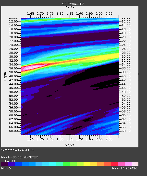
| Estimated Moho Depth: |
35.25 km |
| Estimated Crust Vp/Vs: |
1.66 |
| Assumed Crust Vp: |
6.483 km/s |
| Estimated Crust Vs: |
3.905 km/s |
| Estimated Crust Poisson's Ratio: |
0.22 |
|
| Radial Match: |
86.461136 % |
| Radial Bump: |
400 |
| Transverse Match: |
69.60949 % |
| Transverse Bump: |
400 |
| SOD ConfigId: |
31937991 |
| Insert Time: |
2023-11-14 11:35:21.719 +0000 |
| GWidth: |
2.5 |
| Max Bumps: |
400 |
| Tol: |
0.001 |
|

Signal To Noise
| Channel | StoN | STA | LTA |
| O2:PW06: :HHZ:20231031T11:22:44.395009Z | 1.8188663 | 4.6250315E-7 | 2.54281E-7 |
| O2:PW06: :HHN:20231031T11:22:44.395009Z | 2.2216554 | 6.9522507E-6 | 3.1293112E-6 |
| O2:PW06: :HHE:20231031T11:22:44.395009Z | 0.94935036 | 1.3745198E-6 | 1.447853E-6 |
| Arrivals |
| Ps | 3.7 SECOND |
| PpPs | 14 SECOND |
| PsPs/PpSs | 18 SECOND |


