You are here: Home > Network List > RV - Regional Alberta Seismic Observatory for Earthquake Studies Network Stations List
> Station THORA Thorhild, AB > Earthquake Result Viewer
THORA Thorhild, AB - Earthquake Result Viewer
| Earthquake location: |
Fiji Islands Region |
| Earthquake latitude/longitude: |
-17.5/-179.0 |
| Earthquake time(UTC): |
2023/10/31 (304) 11:10:56 GMT |
| Earthquake Depth: |
548 km |
| Earthquake Magnitude: |
6.4 mww |
| Earthquake Catalog/Contributor: |
NEIC PDE/us |
|
| Network: |
RV Regional Alberta Seismic Observatory for Earthquake Studies Network |
| Station: |
THORA Thorhild, AB |
| Lat/Lon: |
54.20 N/113.21 W |
| Elevation: |
640 m |
|
| Distance: |
90.7 deg |
| Az: |
32.406 deg |
| Baz: |
240.496 deg |
| Ray Param: |
0.041398626 |
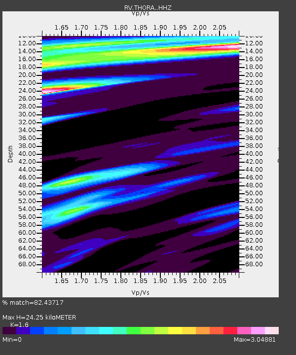
| Estimated Moho Depth: |
24.25 km |
| Estimated Crust Vp/Vs: |
1.60 |
| Assumed Crust Vp: |
6.444 km/s |
| Estimated Crust Vs: |
4.027 km/s |
| Estimated Crust Poisson's Ratio: |
0.18 |
|
| Radial Match: |
82.43717 % |
| Radial Bump: |
400 |
| Transverse Match: |
54.507435 % |
| Transverse Bump: |
371 |
| SOD ConfigId: |
31937991 |
| Insert Time: |
2023-11-14 11:37:46.354 +0000 |
| GWidth: |
2.5 |
| Max Bumps: |
400 |
| Tol: |
0.001 |
|

Signal To Noise
| Channel | StoN | STA | LTA |
| RV:THORA: :HHZ:20231031T11:22:29.280019Z | 2.3914647 | 1.1545395E-6 | 4.82775E-7 |
| RV:THORA: :HHN:20231031T11:22:29.280019Z | 0.5504848 | 4.2936708E-7 | 7.799799E-7 |
| RV:THORA: :HHE:20231031T11:22:29.280019Z | 1.4557217 | 1.0684346E-6 | 7.3395523E-7 |
| Arrivals |
| Ps | 2.3 SECOND |
| PpPs | 9.6 SECOND |
| PsPs/PpSs | 12 SECOND |


