You are here: Home > Network List > TM - Thai Seismic Monitoring Network Stations List
> Station CHBT Khereethan Dam, Chanthaburi > Earthquake Result Viewer
CHBT Khereethan Dam, Chanthaburi - Earthquake Result Viewer
| Earthquake location: |
Fiji Islands Region |
| Earthquake latitude/longitude: |
-17.5/-179.0 |
| Earthquake time(UTC): |
2023/10/31 (304) 11:10:56 GMT |
| Earthquake Depth: |
548 km |
| Earthquake Magnitude: |
6.4 mww |
| Earthquake Catalog/Contributor: |
NEIC PDE/us |
|
| Network: |
TM Thai Seismic Monitoring Network |
| Station: |
CHBT Khereethan Dam, Chanthaburi |
| Lat/Lon: |
12.74 N/102.35 E |
| Elevation: |
198 m |
|
| Distance: |
83.2 deg |
| Az: |
285.58 deg |
| Baz: |
109.619 deg |
| Ray Param: |
0.04473199 |
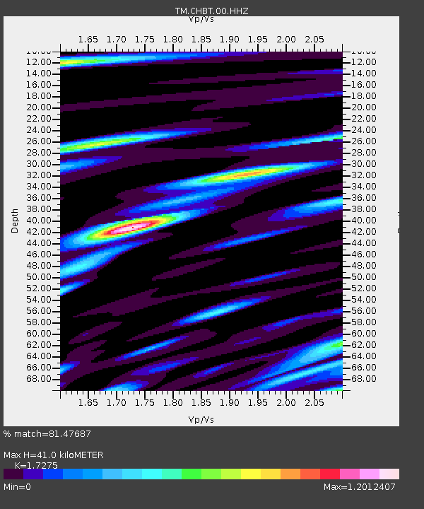
| Estimated Moho Depth: |
41.0 km |
| Estimated Crust Vp/Vs: |
1.73 |
| Assumed Crust Vp: |
6.498 km/s |
| Estimated Crust Vs: |
3.761 km/s |
| Estimated Crust Poisson's Ratio: |
0.25 |
|
| Radial Match: |
81.47687 % |
| Radial Bump: |
400 |
| Transverse Match: |
75.57946 % |
| Transverse Bump: |
400 |
| SOD ConfigId: |
31937991 |
| Insert Time: |
2023-11-14 11:39:19.667 +0000 |
| GWidth: |
2.5 |
| Max Bumps: |
400 |
| Tol: |
0.001 |
|

Signal To Noise
| Channel | StoN | STA | LTA |
| TM:CHBT:00:HHZ:20231031T11:21:53.929982Z | 42.718517 | 5.751214E-6 | 1.3463047E-7 |
| TM:CHBT:00:HHN:20231031T11:21:53.929982Z | 5.468186 | 1.1874356E-6 | 2.1715347E-7 |
| TM:CHBT:00:HHE:20231031T11:21:53.929982Z | 4.9352164 | 1.7970774E-6 | 3.6413346E-7 |
| Arrivals |
| Ps | 4.7 SECOND |
| PpPs | 17 SECOND |
| PsPs/PpSs | 21 SECOND |


