You are here: Home > Network List > US - United States National Seismic Network Stations List
> Station OGNE Ogallala, Nebraska, USA > Earthquake Result Viewer
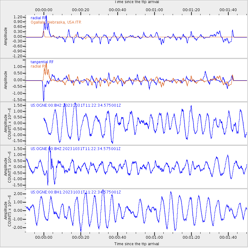
OGNE Ogallala, Nebraska, USA - Earthquake Result Viewer
*The percent match for this event was below the threshold and hence no stack was calculated.
| Earthquake location: |
Fiji Islands Region |
| Earthquake latitude/longitude: |
-17.5/-179.0 |
| Earthquake time(UTC): |
2023/10/31 (304) 11:10:56 GMT |
| Earthquake Depth: |
548 km |
| Earthquake Magnitude: |
6.4 mww |
| Earthquake Catalog/Contributor: |
NEIC PDE/us |
|
| Network: |
US United States National Seismic Network |
| Station: |
OGNE Ogallala, Nebraska, USA |
| Lat/Lon: |
40.95 N/102.03 W |
| Elevation: |
1054 m |
|
| Distance: |
91.9 deg |
| Az: |
47.598 deg |
| Baz: |
248.444 deg |
| Ray Param: |
$rayparam |
*The percent match for this event was below the threshold and hence was not used in the summary stack. |
|
| Radial Match: |
75.904274 % |
| Radial Bump: |
400 |
| Transverse Match: |
55.879223 % |
| Transverse Bump: |
400 |
| SOD ConfigId: |
31937991 |
| Insert Time: |
2023-11-14 11:43:55.451 +0000 |
| GWidth: |
2.5 |
| Max Bumps: |
400 |
| Tol: |
0.001 |
|
Signal To Noise
| Channel | StoN | STA | LTA |
| US:OGNE:00:BHZ:20231031T11:22:34.575001Z | 1.8795123 | 8.1698795E-7 | 4.3468083E-7 |
| US:OGNE:00:BH1:20231031T11:22:34.575001Z | 0.91305333 | 9.682169E-7 | 1.0604166E-6 |
| US:OGNE:00:BH2:20231031T11:22:34.575001Z | 0.76806927 | 6.9383304E-7 | 9.03347E-7 |
| Arrivals |
| Ps | |
| PpPs | |
| PsPs/PpSs | |


