You are here: Home > Network List > UW - Pacific Northwest Regional Seismic Network Stations List
> Station PASS Maple Falls, WA, USA > Earthquake Result Viewer
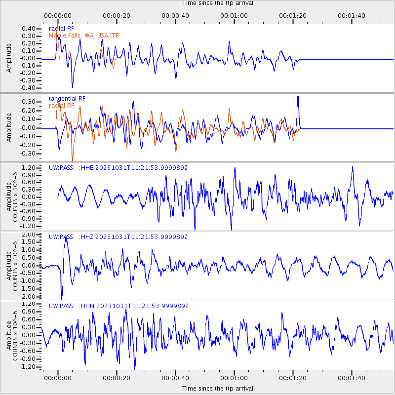
PASS Maple Falls, WA, USA - Earthquake Result Viewer
*The percent match for this event was below the threshold and hence no stack was calculated.
| Earthquake location: |
Fiji Islands Region |
| Earthquake latitude/longitude: |
-17.5/-179.0 |
| Earthquake time(UTC): |
2023/10/31 (304) 11:10:56 GMT |
| Earthquake Depth: |
548 km |
| Earthquake Magnitude: |
6.4 mww |
| Earthquake Catalog/Contributor: |
NEIC PDE/us |
|
| Network: |
UW Pacific Northwest Regional Seismic Network |
| Station: |
PASS Maple Falls, WA, USA |
| Lat/Lon: |
49.00 N/122.09 W |
| Elevation: |
174 m |
|
| Distance: |
83.3 deg |
| Az: |
33.761 deg |
| Baz: |
233.619 deg |
| Ray Param: |
$rayparam |
*The percent match for this event was below the threshold and hence was not used in the summary stack. |
|
| Radial Match: |
70.42461 % |
| Radial Bump: |
400 |
| Transverse Match: |
63.878746 % |
| Transverse Bump: |
400 |
| SOD ConfigId: |
31937991 |
| Insert Time: |
2023-11-14 11:47:11.331 +0000 |
| GWidth: |
2.5 |
| Max Bumps: |
400 |
| Tol: |
0.001 |
|
Signal To Noise
| Channel | StoN | STA | LTA |
| UW:PASS: :HHZ:20231031T11:21:53.999989Z | 4.2711396 | 1.0322165E-6 | 2.4167238E-7 |
| UW:PASS: :HHN:20231031T11:21:53.999989Z | 1.3979855 | 2.7572935E-7 | 1.9723333E-7 |
| UW:PASS: :HHE:20231031T11:21:53.999989Z | 1.7327688 | 4.140201E-7 | 2.3893557E-7 |
| Arrivals |
| Ps | |
| PpPs | |
| PsPs/PpSs | |


