You are here: Home > Network List > IW - Intermountain West Stations List
> Station MOOW Moose Ponds, Wyoming, USA > Earthquake Result Viewer
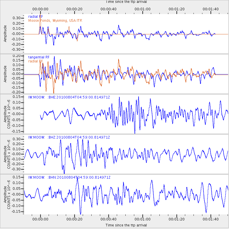
MOOW Moose Ponds, Wyoming, USA - Earthquake Result Viewer
*The percent match for this event was below the threshold and hence no stack was calculated.
| Earthquake location: |
South Of Fiji Islands |
| Earthquake latitude/longitude: |
-26.9/-177.2 |
| Earthquake time(UTC): |
2010/08/04 (216) 04:46:20 GMT |
| Earthquake Depth: |
18 km |
| Earthquake Magnitude: |
5.7 MB, 5.8 MS, 6.0 MW, 5.9 MW |
| Earthquake Catalog/Contributor: |
WHDF/NEIC |
|
| Network: |
IW Intermountain West |
| Station: |
MOOW Moose Ponds, Wyoming, USA |
| Lat/Lon: |
43.75 N/110.74 W |
| Elevation: |
2128 m |
|
| Distance: |
93.0 deg |
| Az: |
41.72 deg |
| Baz: |
235.08 deg |
| Ray Param: |
$rayparam |
*The percent match for this event was below the threshold and hence was not used in the summary stack. |
|
| Radial Match: |
66.881195 % |
| Radial Bump: |
400 |
| Transverse Match: |
66.98342 % |
| Transverse Bump: |
400 |
| SOD ConfigId: |
319893 |
| Insert Time: |
2011-01-05 15:42:33.536 +0000 |
| GWidth: |
2.5 |
| Max Bumps: |
400 |
| Tol: |
0.001 |
|
Signal To Noise
| Channel | StoN | STA | LTA |
| IW:MOOW: :BHZ:20100804T04:59:00.814971Z | 2.0208163 | 8.803129E-8 | 4.3562245E-8 |
| IW:MOOW: :BHN:20100804T04:59:00.814971Z | 0.8413067 | 2.625202E-8 | 3.1203864E-8 |
| IW:MOOW: :BHE:20100804T04:59:00.814971Z | 0.57601833 | 1.6271358E-8 | 2.8247985E-8 |
| Arrivals |
| Ps | |
| PpPs | |
| PsPs/PpSs | |


