You are here: Home > Network List > TA - USArray Transportable Network (new EarthScope stations) Stations List
> Station R26A Arlington, CO, USA > Earthquake Result Viewer
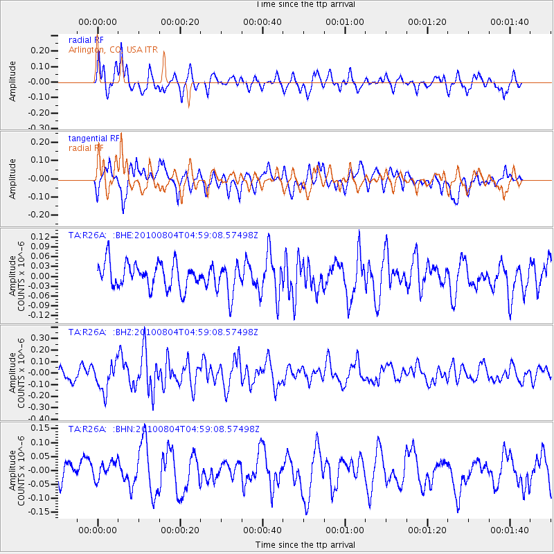
R26A Arlington, CO, USA - Earthquake Result Viewer
*The percent match for this event was below the threshold and hence no stack was calculated.
| Earthquake location: |
South Of Fiji Islands |
| Earthquake latitude/longitude: |
-26.9/-177.2 |
| Earthquake time(UTC): |
2010/08/04 (216) 04:46:20 GMT |
| Earthquake Depth: |
18 km |
| Earthquake Magnitude: |
5.7 MB, 5.8 MS, 6.0 MW, 5.9 MW |
| Earthquake Catalog/Contributor: |
WHDF/NEIC |
|
| Network: |
TA USArray Transportable Network (new EarthScope stations) |
| Station: |
R26A Arlington, CO, USA |
| Lat/Lon: |
38.30 N/103.45 W |
| Elevation: |
1304 m |
|
| Distance: |
94.7 deg |
| Az: |
49.295 deg |
| Baz: |
239.352 deg |
| Ray Param: |
$rayparam |
*The percent match for this event was below the threshold and hence was not used in the summary stack. |
|
| Radial Match: |
59.978874 % |
| Radial Bump: |
375 |
| Transverse Match: |
72.78704 % |
| Transverse Bump: |
400 |
| SOD ConfigId: |
319893 |
| Insert Time: |
2011-01-05 15:46:24.014 +0000 |
| GWidth: |
2.5 |
| Max Bumps: |
400 |
| Tol: |
0.001 |
|
Signal To Noise
| Channel | StoN | STA | LTA |
| TA:R26A: :BHZ:20100804T04:59:08.57498Z | 1.9584339 | 1.2431347E-7 | 6.347596E-8 |
| TA:R26A: :BHN:20100804T04:59:08.57498Z | 0.8749382 | 3.5026073E-8 | 4.0032628E-8 |
| TA:R26A: :BHE:20100804T04:59:08.57498Z | 1.3588531 | 5.169506E-8 | 3.8043154E-8 |
| Arrivals |
| Ps | |
| PpPs | |
| PsPs/PpSs | |


