You are here: Home > Network List > CU - Caribbean Network (USGS) Stations List
> Station GTBY Guantanamo Bay, Cuba > Earthquake Result Viewer
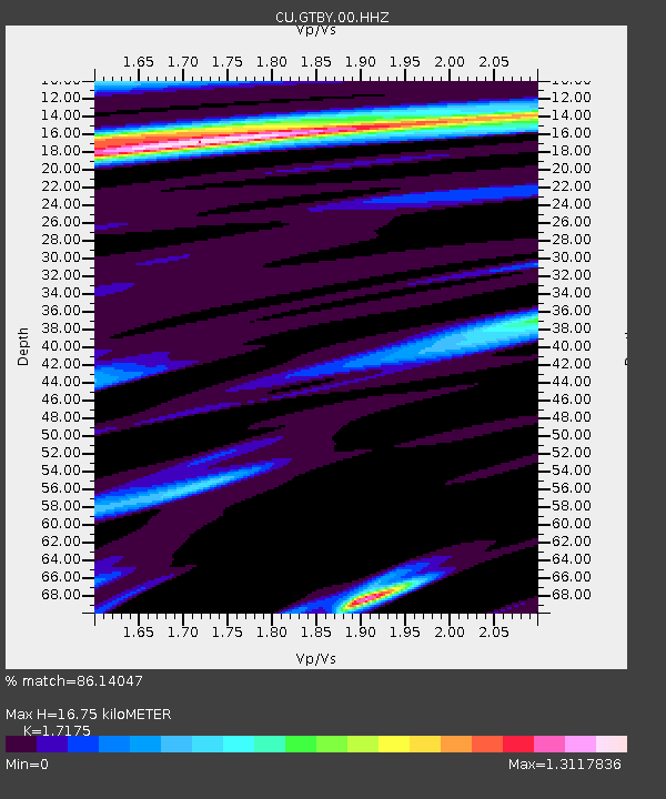
GTBY Guantanamo Bay, Cuba - Earthquake Result Viewer
| Earthquake location: |
Near Coast Of Central Chile |
| Earthquake latitude/longitude: |
-28.7/-71.6 |
| Earthquake time(UTC): |
2023/10/31 (304) 12:33:44 GMT |
| Earthquake Depth: |
41 km |
| Earthquake Magnitude: |
6.7 mww |
| Earthquake Catalog/Contributor: |
NEIC PDE/us |
|
| Network: |
CU Caribbean Network (USGS) |
| Station: |
GTBY Guantanamo Bay, Cuba |
| Lat/Lon: |
19.93 N/75.11 W |
| Elevation: |
79 m |
|
| Distance: |
48.5 deg |
| Az: |
355.554 deg |
| Baz: |
175.851 deg |
| Ray Param: |
0.06922575 |
| Estimated Moho Depth: |
16.75 km |
| Estimated Crust Vp/Vs: |
1.72 |
| Assumed Crust Vp: |
6.048 km/s |
| Estimated Crust Vs: |
3.521 km/s |
| Estimated Crust Poisson's Ratio: |
0.24 |
|
| Radial Match: |
86.14047 % |
| Radial Bump: |
400 |
| Transverse Match: |
78.55897 % |
| Transverse Bump: |
400 |
| SOD ConfigId: |
31937991 |
| Insert Time: |
2023-11-14 12:43:41.301 +0000 |
| GWidth: |
2.5 |
| Max Bumps: |
400 |
| Tol: |
0.001 |
|

Signal To Noise
| Channel | StoN | STA | LTA |
| CU:GTBY:00:HHZ:20231031T12:41:52.598013Z | 3.5388436 | 6.393412E-7 | 1.8066386E-7 |
| CU:GTBY:00:HH1:20231031T12:41:52.598013Z | 2.3364277 | 2.9129234E-7 | 1.2467424E-7 |
| CU:GTBY:00:HH2:20231031T12:41:52.598013Z | 1.1888366 | 1.9487759E-7 | 1.6392293E-7 |
| Arrivals |
| Ps | 2.1 SECOND |
| PpPs | 7.1 SECOND |
| PsPs/PpSs | 9.2 SECOND |


