You are here: Home > Network List > G - GEOSCOPE Stations List
> Station FDFM Morne la Rosette, Martinique, France > Earthquake Result Viewer
FDFM Morne la Rosette, Martinique, France - Earthquake Result Viewer
| Earthquake location: |
Near Coast Of Central Chile |
| Earthquake latitude/longitude: |
-28.7/-71.6 |
| Earthquake time(UTC): |
2023/10/31 (304) 12:33:44 GMT |
| Earthquake Depth: |
41 km |
| Earthquake Magnitude: |
6.7 mww |
| Earthquake Catalog/Contributor: |
NEIC PDE/us |
|
| Network: |
G GEOSCOPE |
| Station: |
FDFM Morne la Rosette, Martinique, France |
| Lat/Lon: |
14.73 N/61.16 W |
| Elevation: |
320 m |
|
| Distance: |
44.4 deg |
| Az: |
14.478 deg |
| Baz: |
193.115 deg |
| Ray Param: |
0.07187141 |
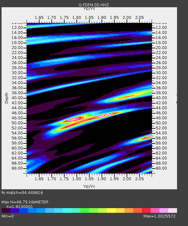
| Estimated Moho Depth: |
46.75 km |
| Estimated Crust Vp/Vs: |
1.91 |
| Assumed Crust Vp: |
5.88 km/s |
| Estimated Crust Vs: |
3.079 km/s |
| Estimated Crust Poisson's Ratio: |
0.31 |
|
| Radial Match: |
84.448616 % |
| Radial Bump: |
400 |
| Transverse Match: |
65.70018 % |
| Transverse Bump: |
400 |
| SOD ConfigId: |
31937991 |
| Insert Time: |
2023-11-14 12:44:18.638 +0000 |
| GWidth: |
2.5 |
| Max Bumps: |
400 |
| Tol: |
0.001 |
|

Signal To Noise
| Channel | StoN | STA | LTA |
| G:FDFM:00:HHZ:20231031T12:41:20.309988Z | 12.66729 | 2.7469698E-6 | 2.1685538E-7 |
| G:FDFM:00:HHN:20231031T12:41:20.309988Z | 4.9794364 | 1.6730534E-6 | 3.359925E-7 |
| G:FDFM:00:HHE:20231031T12:41:20.309988Z | 3.9413717 | 1.5045044E-6 | 3.81721E-7 |
| Arrivals |
| Ps | 7.6 SECOND |
| PpPs | 22 SECOND |
| PsPs/PpSs | 30 SECOND |


