You are here: Home > Network List > IU - Global Seismograph Network (GSN - IRIS/USGS) Stations List
> Station PMSA Palmer Station, Antarctica > Earthquake Result Viewer
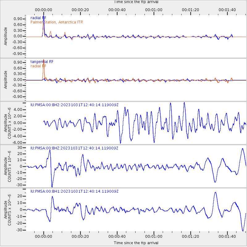
PMSA Palmer Station, Antarctica - Earthquake Result Viewer

| Earthquake location: |
Near Coast Of Central Chile |
| Earthquake latitude/longitude: |
-28.7/-71.6 |
| Earthquake time(UTC): |
2023/10/31 (304) 12:33:44 GMT |
| Earthquake Depth: |
41 km |
| Earthquake Magnitude: |
6.7 mww |
| Earthquake Catalog/Contributor: |
NEIC PDE/us |
|
| Network: |
IU Global Seismograph Network (GSN - IRIS/USGS) |
| Station: |
PMSA Palmer Station, Antarctica |
| Lat/Lon: |
64.77 S/64.05 W |
| Elevation: |
40 m |
|
| Distance: |
36.4 deg |
| Az: |
174.569 deg |
| Baz: |
348.816 deg |
| Ray Param: |
0.07666596 |
| Estimated Moho Depth: |
43.75 km |
| Estimated Crust Vp/Vs: |
1.85 |
| Assumed Crust Vp: |
6.183 km/s |
| Estimated Crust Vs: |
3.342 km/s |
| Estimated Crust Poisson's Ratio: |
0.29 |
|
| Radial Match: |
91.506424 % |
| Radial Bump: |
370 |
| Transverse Match: |
70.95638 % |
| Transverse Bump: |
400 |
| SOD ConfigId: |
31937991 |
| Insert Time: |
2023-11-14 12:46:05.232 +0000 |
| GWidth: |
2.5 |
| Max Bumps: |
400 |
| Tol: |
0.001 |
|
Signal To Noise
| Channel | StoN | STA | LTA |
| IU:PMSA:00:BHZ:20231031T12:40:14.119009Z | 16.707521 | 1.5439857E-5 | 9.2412614E-7 |
| IU:PMSA:00:BH1:20231031T12:40:14.119009Z | 13.991774 | 9.808995E-6 | 7.0105443E-7 |
| IU:PMSA:00:BH2:20231031T12:40:14.119009Z | 1.7959225 | 1.5370333E-6 | 8.558461E-7 |
| Arrivals |
| Ps | 6.4 SECOND |
| PpPs | 19 SECOND |
| PsPs/PpSs | 25 SECOND |


