You are here: Home > Network List > IW - Intermountain West Stations List
> Station MOOW Moose Ponds, Wyoming, USA > Earthquake Result Viewer
MOOW Moose Ponds, Wyoming, USA - Earthquake Result Viewer
| Earthquake location: |
Near Coast Of Central Chile |
| Earthquake latitude/longitude: |
-28.7/-71.6 |
| Earthquake time(UTC): |
2023/10/31 (304) 12:33:44 GMT |
| Earthquake Depth: |
41 km |
| Earthquake Magnitude: |
6.7 mww |
| Earthquake Catalog/Contributor: |
NEIC PDE/us |
|
| Network: |
IW Intermountain West |
| Station: |
MOOW Moose Ponds, Wyoming, USA |
| Lat/Lon: |
43.75 N/110.74 W |
| Elevation: |
2128 m |
|
| Distance: |
80.6 deg |
| Az: |
332.354 deg |
| Baz: |
145.789 deg |
| Ray Param: |
0.048118256 |
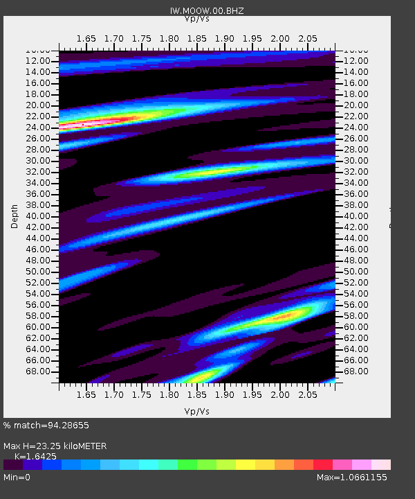
| Estimated Moho Depth: |
23.25 km |
| Estimated Crust Vp/Vs: |
1.64 |
| Assumed Crust Vp: |
6.207 km/s |
| Estimated Crust Vs: |
3.779 km/s |
| Estimated Crust Poisson's Ratio: |
0.21 |
|
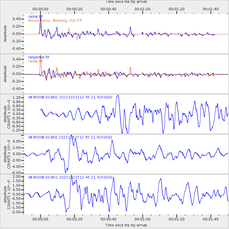
| Radial Match: |
94.28655 % |
| Radial Bump: |
400 |
| Transverse Match: |
68.93849 % |
| Transverse Bump: |
400 |
| SOD ConfigId: |
31937991 |
| Insert Time: |
2023-11-14 12:46:26.755 +0000 |
| GWidth: |
2.5 |
| Max Bumps: |
400 |
| Tol: |
0.001 |
|
Signal To Noise
| Channel | StoN | STA | LTA |
| IW:MOOW:00:BHZ:20231031T12:45:21.425009Z | 2.9373465 | 6.431017E-7 | 2.1893968E-7 |
| IW:MOOW:00:BH1:20231031T12:45:21.425009Z | 1.5228175 | 1.9385628E-7 | 1.2730105E-7 |
| IW:MOOW:00:BH2:20231031T12:45:21.425009Z | 1.1893425 | 2.4107982E-7 | 2.027001E-7 |
| Arrivals |
| Ps | 2.5 SECOND |
| PpPs | 9.6 SECOND |
| PsPs/PpSs | 12 SECOND |


