You are here: Home > Network List > MB - Montana Regional Seismic Network Stations List
> Station LIMT Lima, MT > Earthquake Result Viewer
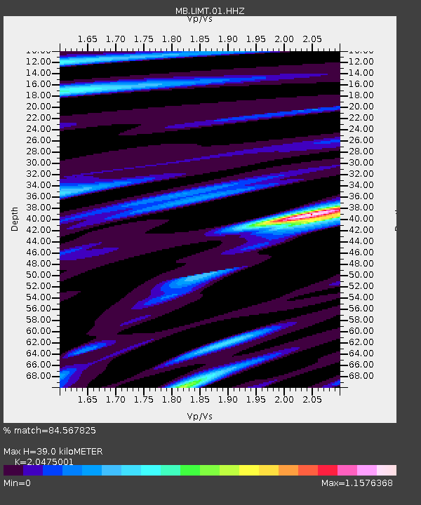
LIMT Lima, MT - Earthquake Result Viewer
| Earthquake location: |
Near Coast Of Central Chile |
| Earthquake latitude/longitude: |
-28.7/-71.6 |
| Earthquake time(UTC): |
2023/10/31 (304) 12:33:44 GMT |
| Earthquake Depth: |
41 km |
| Earthquake Magnitude: |
6.7 mww |
| Earthquake Catalog/Contributor: |
NEIC PDE/us |
|
| Network: |
MB Montana Regional Seismic Network |
| Station: |
LIMT Lima, MT |
| Lat/Lon: |
44.62 N/112.64 W |
| Elevation: |
1956 m |
|
| Distance: |
82.1 deg |
| Az: |
331.723 deg |
| Baz: |
144.374 deg |
| Ray Param: |
0.047079474 |
| Estimated Moho Depth: |
39.0 km |
| Estimated Crust Vp/Vs: |
2.05 |
| Assumed Crust Vp: |
6.577 km/s |
| Estimated Crust Vs: |
3.212 km/s |
| Estimated Crust Poisson's Ratio: |
0.34 |
|
| Radial Match: |
84.567825 % |
| Radial Bump: |
400 |
| Transverse Match: |
55.270844 % |
| Transverse Bump: |
400 |
| SOD ConfigId: |
31937991 |
| Insert Time: |
2023-11-14 12:47:16.982 +0000 |
| GWidth: |
2.5 |
| Max Bumps: |
400 |
| Tol: |
0.001 |
|

Signal To Noise
| Channel | StoN | STA | LTA |
| MB:LIMT:01:HHZ:20231031T12:45:29.310019Z | 5.0910325 | 1.4296838E-6 | 2.8082394E-7 |
| MB:LIMT:01:HHN:20231031T12:45:29.310019Z | 2.404263 | 9.08757E-7 | 3.7797736E-7 |
| MB:LIMT:01:HHE:20231031T12:45:29.310019Z | 1.0628743 | 6.967589E-7 | 6.555421E-7 |
| Arrivals |
| Ps | 6.4 SECOND |
| PpPs | 18 SECOND |
| PsPs/PpSs | 24 SECOND |


