You are here: Home > Network List > MB - Montana Regional Seismic Network Stations List
> Station LRM Limekiln Ridge > Earthquake Result Viewer
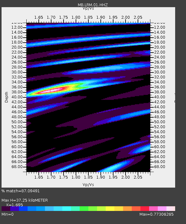
LRM Limekiln Ridge - Earthquake Result Viewer
| Earthquake location: |
Near Coast Of Central Chile |
| Earthquake latitude/longitude: |
-28.7/-71.6 |
| Earthquake time(UTC): |
2023/10/31 (304) 12:33:44 GMT |
| Earthquake Depth: |
41 km |
| Earthquake Magnitude: |
6.7 mww |
| Earthquake Catalog/Contributor: |
NEIC PDE/us |
|
| Network: |
MB Montana Regional Seismic Network |
| Station: |
LRM Limekiln Ridge |
| Lat/Lon: |
45.82 N/112.45 W |
| Elevation: |
2329 m |
|
| Distance: |
83.0 deg |
| Az: |
332.54 deg |
| Baz: |
144.617 deg |
| Ray Param: |
0.046453103 |
| Estimated Moho Depth: |
37.25 km |
| Estimated Crust Vp/Vs: |
1.70 |
| Assumed Crust Vp: |
6.577 km/s |
| Estimated Crust Vs: |
3.88 km/s |
| Estimated Crust Poisson's Ratio: |
0.23 |
|
| Radial Match: |
87.09491 % |
| Radial Bump: |
400 |
| Transverse Match: |
64.31321 % |
| Transverse Bump: |
400 |
| SOD ConfigId: |
31937991 |
| Insert Time: |
2023-11-14 12:47:22.950 +0000 |
| GWidth: |
2.5 |
| Max Bumps: |
400 |
| Tol: |
0.001 |
|

Signal To Noise
| Channel | StoN | STA | LTA |
| MB:LRM:01:HHZ:20231031T12:45:33.990011Z | 1.8602955 | 6.661581E-7 | 3.580926E-7 |
| MB:LRM:01:HHN:20231031T12:45:33.990011Z | 1.0544356 | 3.902767E-7 | 3.7012853E-7 |
| MB:LRM:01:HHE:20231031T12:45:33.990011Z | 0.4078567 | 1.8091444E-7 | 4.4357353E-7 |
| Arrivals |
| Ps | 4.0 SECOND |
| PpPs | 15 SECOND |
| PsPs/PpSs | 19 SECOND |


