You are here: Home > Network List > TA - USArray Transportable Network (new EarthScope stations) Stations List
> Station S28A Manter, KS, USA > Earthquake Result Viewer
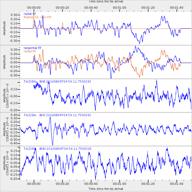
S28A Manter, KS, USA - Earthquake Result Viewer
*The percent match for this event was below the threshold and hence no stack was calculated.
| Earthquake location: |
South Of Fiji Islands |
| Earthquake latitude/longitude: |
-26.9/-177.2 |
| Earthquake time(UTC): |
2010/08/04 (216) 04:46:20 GMT |
| Earthquake Depth: |
18 km |
| Earthquake Magnitude: |
5.7 MB, 5.8 MS, 6.0 MW, 5.9 MW |
| Earthquake Catalog/Contributor: |
WHDF/NEIC |
|
| Network: |
TA USArray Transportable Network (new EarthScope stations) |
| Station: |
S28A Manter, KS, USA |
| Lat/Lon: |
37.59 N/101.90 W |
| Elevation: |
1064 m |
|
| Distance: |
95.4 deg |
| Az: |
50.53 deg |
| Baz: |
240.192 deg |
| Ray Param: |
$rayparam |
*The percent match for this event was below the threshold and hence was not used in the summary stack. |
|
| Radial Match: |
48.21502 % |
| Radial Bump: |
400 |
| Transverse Match: |
47.07415 % |
| Transverse Bump: |
400 |
| SOD ConfigId: |
319893 |
| Insert Time: |
2011-01-05 15:49:03.609 +0000 |
| GWidth: |
2.5 |
| Max Bumps: |
400 |
| Tol: |
0.001 |
|
Signal To Noise
| Channel | StoN | STA | LTA |
| TA:S28A: :BHZ:20100804T04:59:11.750029Z | 2.5946467 | 1.4052485E-7 | 5.4159532E-8 |
| TA:S28A: :BHN:20100804T04:59:11.750029Z | 1.7810922 | 1.10999636E-7 | 6.232111E-8 |
| TA:S28A: :BHE:20100804T04:59:11.750029Z | 1.0639151 | 9.076887E-8 | 8.53159E-8 |
| Arrivals |
| Ps | |
| PpPs | |
| PsPs/PpSs | |


