You are here: Home > Network List > N4 - Central and EAstern US Network Stations List
> Station J61A Chester > Earthquake Result Viewer
J61A Chester - Earthquake Result Viewer
| Earthquake location: |
Near Coast Of Central Chile |
| Earthquake latitude/longitude: |
-28.7/-71.6 |
| Earthquake time(UTC): |
2023/10/31 (304) 12:33:44 GMT |
| Earthquake Depth: |
41 km |
| Earthquake Magnitude: |
6.7 mww |
| Earthquake Catalog/Contributor: |
NEIC PDE/us |
|
| Network: |
N4 Central and EAstern US Network |
| Station: |
J61A Chester |
| Lat/Lon: |
43.35 N/72.55 W |
| Elevation: |
253 m |
|
| Distance: |
71.7 deg |
| Az: |
359.247 deg |
| Baz: |
179.093 deg |
| Ray Param: |
0.05406348 |
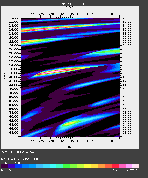
| Estimated Moho Depth: |
37.25 km |
| Estimated Crust Vp/Vs: |
1.76 |
| Assumed Crust Vp: |
6.419 km/s |
| Estimated Crust Vs: |
3.652 km/s |
| Estimated Crust Poisson's Ratio: |
0.26 |
|
| Radial Match: |
83.216156 % |
| Radial Bump: |
315 |
| Transverse Match: |
77.98418 % |
| Transverse Bump: |
400 |
| SOD ConfigId: |
31937991 |
| Insert Time: |
2023-11-14 12:48:28.540 +0000 |
| GWidth: |
2.5 |
| Max Bumps: |
400 |
| Tol: |
0.001 |
|

Signal To Noise
| Channel | StoN | STA | LTA |
| N4:J61A:00:HHZ:20231031T12:44:31.380026Z | 3.445738 | 2.5069446E-6 | 7.275494E-7 |
| N4:J61A:00:HH1:20231031T12:44:31.380026Z | 2.1839592 | 1.2655253E-6 | 5.7946374E-7 |
| N4:J61A:00:HH2:20231031T12:44:31.380026Z | 1.0679994 | 5.0432203E-7 | 4.722119E-7 |
| Arrivals |
| Ps | 4.6 SECOND |
| PpPs | 15 SECOND |
| PsPs/PpSs | 20 SECOND |


