You are here: Home > Network List > N4 - Central and EAstern US Network Stations List
> Station V55A Morning Dew, Taylorsville, NC, USA > Earthquake Result Viewer
V55A Morning Dew, Taylorsville, NC, USA - Earthquake Result Viewer
| Earthquake location: |
Near Coast Of Central Chile |
| Earthquake latitude/longitude: |
-28.7/-71.6 |
| Earthquake time(UTC): |
2023/10/31 (304) 12:33:44 GMT |
| Earthquake Depth: |
41 km |
| Earthquake Magnitude: |
6.7 mww |
| Earthquake Catalog/Contributor: |
NEIC PDE/us |
|
| Network: |
N4 Central and EAstern US Network |
| Station: |
V55A Morning Dew, Taylorsville, NC, USA |
| Lat/Lon: |
35.85 N/81.21 W |
| Elevation: |
313 m |
|
| Distance: |
64.9 deg |
| Az: |
351.357 deg |
| Baz: |
170.652 deg |
| Ray Param: |
0.058557987 |
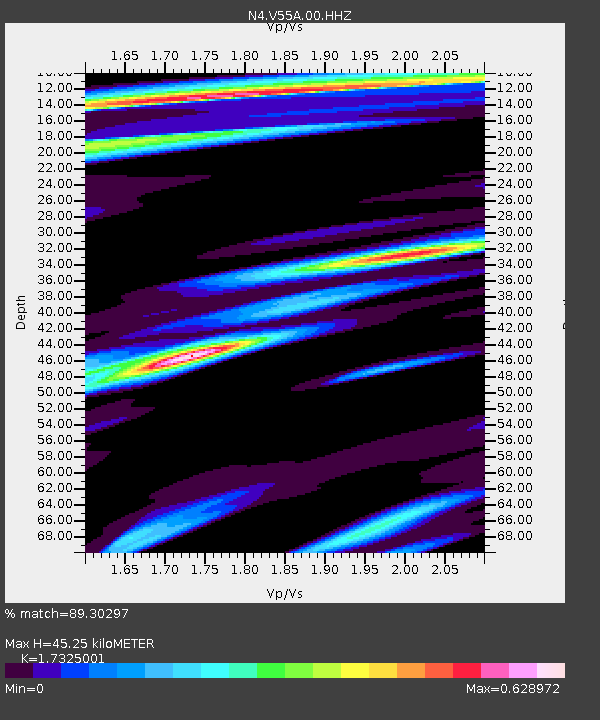
| Estimated Moho Depth: |
45.25 km |
| Estimated Crust Vp/Vs: |
1.73 |
| Assumed Crust Vp: |
6.419 km/s |
| Estimated Crust Vs: |
3.705 km/s |
| Estimated Crust Poisson's Ratio: |
0.25 |
|
| Radial Match: |
89.30297 % |
| Radial Bump: |
400 |
| Transverse Match: |
57.02176 % |
| Transverse Bump: |
400 |
| SOD ConfigId: |
31937991 |
| Insert Time: |
2023-11-14 12:50:15.559 +0000 |
| GWidth: |
2.5 |
| Max Bumps: |
400 |
| Tol: |
0.001 |
|

Signal To Noise
| Channel | StoN | STA | LTA |
| N4:V55A:00:HHZ:20231031T12:43:48.638998Z | 6.6007953 | 1.5849166E-6 | 2.4010996E-7 |
| N4:V55A:00:HH1:20231031T12:43:48.638998Z | 3.4019434 | 6.878978E-7 | 2.0220729E-7 |
| N4:V55A:00:HH2:20231031T12:43:48.638998Z | 0.7888469 | 2.5235178E-7 | 3.1989958E-7 |
| Arrivals |
| Ps | 5.4 SECOND |
| PpPs | 18 SECOND |
| PsPs/PpSs | 24 SECOND |


