You are here: Home > Network List > TA - USArray Transportable Network (new EarthScope stations) Stations List
> Station 433A Art, TX, USA > Earthquake Result Viewer
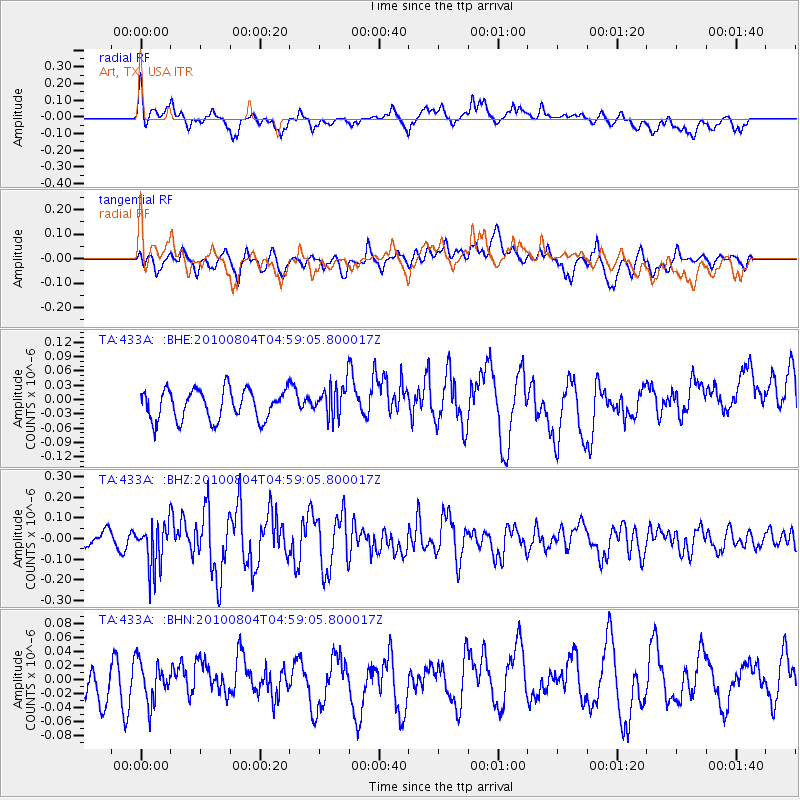
433A Art, TX, USA - Earthquake Result Viewer
*The percent match for this event was below the threshold and hence no stack was calculated.
| Earthquake location: |
South Of Fiji Islands |
| Earthquake latitude/longitude: |
-26.9/-177.2 |
| Earthquake time(UTC): |
2010/08/04 (216) 04:46:20 GMT |
| Earthquake Depth: |
18 km |
| Earthquake Magnitude: |
5.7 MB, 5.8 MS, 6.0 MW, 5.9 MW |
| Earthquake Catalog/Contributor: |
WHDF/NEIC |
|
| Network: |
TA USArray Transportable Network (new EarthScope stations) |
| Station: |
433A Art, TX, USA |
| Lat/Lon: |
30.75 N/99.09 W |
| Elevation: |
447 m |
|
| Distance: |
94.1 deg |
| Az: |
57.638 deg |
| Baz: |
241.176 deg |
| Ray Param: |
$rayparam |
*The percent match for this event was below the threshold and hence was not used in the summary stack. |
|
| Radial Match: |
57.53937 % |
| Radial Bump: |
400 |
| Transverse Match: |
47.57741 % |
| Transverse Bump: |
400 |
| SOD ConfigId: |
319893 |
| Insert Time: |
2011-01-05 15:50:51.201 +0000 |
| GWidth: |
2.5 |
| Max Bumps: |
400 |
| Tol: |
0.001 |
|
Signal To Noise
| Channel | StoN | STA | LTA |
| TA:433A: :BHZ:20100804T04:59:05.800017Z | 2.3634074 | 1.09635415E-7 | 4.6388706E-8 |
| TA:433A: :BHN:20100804T04:59:05.800017Z | 1.3449833 | 2.8974803E-8 | 2.1542872E-8 |
| TA:433A: :BHE:20100804T04:59:05.800017Z | 1.1047214 | 3.506222E-8 | 3.173852E-8 |
| Arrivals |
| Ps | |
| PpPs | |
| PsPs/PpSs | |


