You are here: Home > Network List > N4 - Central and EAstern US Network Stations List
> Station X48A Hartselle, AL, USA > Earthquake Result Viewer
X48A Hartselle, AL, USA - Earthquake Result Viewer
| Earthquake location: |
Near Coast Of Central Chile |
| Earthquake latitude/longitude: |
-28.7/-71.6 |
| Earthquake time(UTC): |
2023/10/31 (304) 12:33:44 GMT |
| Earthquake Depth: |
41 km |
| Earthquake Magnitude: |
6.7 mww |
| Earthquake Catalog/Contributor: |
NEIC PDE/us |
|
| Network: |
N4 Central and EAstern US Network |
| Station: |
X48A Hartselle, AL, USA |
| Lat/Lon: |
34.45 N/87.05 W |
| Elevation: |
180 m |
|
| Distance: |
64.5 deg |
| Az: |
345.867 deg |
| Baz: |
164.962 deg |
| Ray Param: |
0.05878647 |
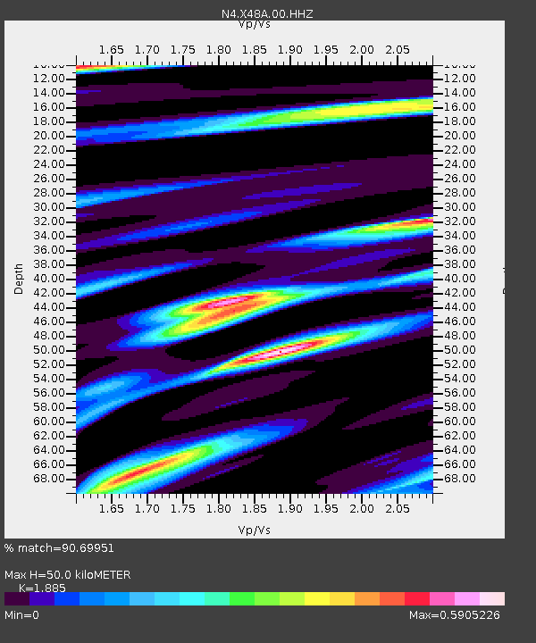
| Estimated Moho Depth: |
50.0 km |
| Estimated Crust Vp/Vs: |
1.88 |
| Assumed Crust Vp: |
6.476 km/s |
| Estimated Crust Vs: |
3.435 km/s |
| Estimated Crust Poisson's Ratio: |
0.30 |
|
| Radial Match: |
90.69951 % |
| Radial Bump: |
305 |
| Transverse Match: |
72.15179 % |
| Transverse Bump: |
400 |
| SOD ConfigId: |
31937991 |
| Insert Time: |
2023-11-14 12:50:24.555 +0000 |
| GWidth: |
2.5 |
| Max Bumps: |
400 |
| Tol: |
0.001 |
|

Signal To Noise
| Channel | StoN | STA | LTA |
| N4:X48A:00:HHZ:20231031T12:43:46.329977Z | 5.10358 | 1.1298033E-6 | 2.2137466E-7 |
| N4:X48A:00:HH1:20231031T12:43:46.329977Z | 3.068367 | 5.7365895E-7 | 1.8695904E-7 |
| N4:X48A:00:HH2:20231031T12:43:46.329977Z | 1.4960593 | 1.8716287E-7 | 1.2510391E-7 |
| Arrivals |
| Ps | 7.1 SECOND |
| PpPs | 21 SECOND |
| PsPs/PpSs | 29 SECOND |


