You are here: Home > Network List > O2 - Oklahoma Consolidated Temporary Seismic Networks Stations List
> Station PW18 Morrison, Oklahoma, USA > Earthquake Result Viewer
PW18 Morrison, Oklahoma, USA - Earthquake Result Viewer
| Earthquake location: |
Near Coast Of Central Chile |
| Earthquake latitude/longitude: |
-28.7/-71.6 |
| Earthquake time(UTC): |
2023/10/31 (304) 12:33:44 GMT |
| Earthquake Depth: |
41 km |
| Earthquake Magnitude: |
6.7 mww |
| Earthquake Catalog/Contributor: |
NEIC PDE/us |
|
| Network: |
O2 Oklahoma Consolidated Temporary Seismic Networks |
| Station: |
PW18 Morrison, Oklahoma, USA |
| Lat/Lon: |
36.28 N/97.04 W |
| Elevation: |
299 m |
|
| Distance: |
69.0 deg |
| Az: |
338.144 deg |
| Baz: |
156.136 deg |
| Ray Param: |
0.055879794 |
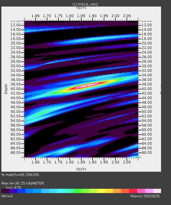
| Estimated Moho Depth: |
38.25 km |
| Estimated Crust Vp/Vs: |
1.88 |
| Assumed Crust Vp: |
6.483 km/s |
| Estimated Crust Vs: |
3.457 km/s |
| Estimated Crust Poisson's Ratio: |
0.30 |
|
| Radial Match: |
88.258255 % |
| Radial Bump: |
314 |
| Transverse Match: |
63.781834 % |
| Transverse Bump: |
322 |
| SOD ConfigId: |
31937991 |
| Insert Time: |
2023-11-14 12:53:20.468 +0000 |
| GWidth: |
2.5 |
| Max Bumps: |
400 |
| Tol: |
0.001 |
|

Signal To Noise
| Channel | StoN | STA | LTA |
| O2:PW18: :HHZ:20231031T12:44:14.534994Z | 4.208977 | 1.199491E-6 | 2.8498394E-7 |
| O2:PW18: :HHN:20231031T12:44:14.534994Z | 1.1834463 | 4.803907E-7 | 4.0592522E-7 |
| O2:PW18: :HHE:20231031T12:44:14.534994Z | 0.6398997 | 3.540463E-7 | 5.5328405E-7 |
| Arrivals |
| Ps | 5.4 SECOND |
| PpPs | 16 SECOND |
| PsPs/PpSs | 22 SECOND |


