You are here: Home > Network List > O2 - Oklahoma Consolidated Temporary Seismic Networks Stations List
> Station SC13 Stratford, Oklahoma, USA > Earthquake Result Viewer
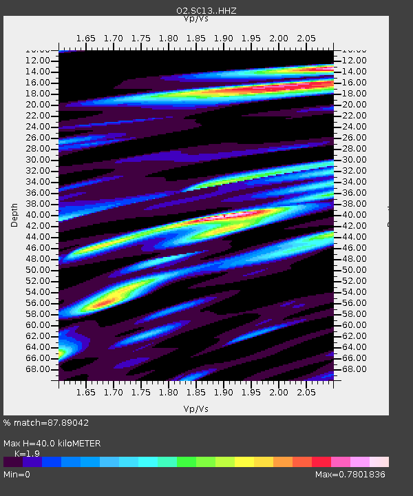
SC13 Stratford, Oklahoma, USA - Earthquake Result Viewer
| Earthquake location: |
Near Coast Of Central Chile |
| Earthquake latitude/longitude: |
-28.7/-71.6 |
| Earthquake time(UTC): |
2023/10/31 (304) 12:33:44 GMT |
| Earthquake Depth: |
41 km |
| Earthquake Magnitude: |
6.7 mww |
| Earthquake Catalog/Contributor: |
NEIC PDE/us |
|
| Network: |
O2 Oklahoma Consolidated Temporary Seismic Networks |
| Station: |
SC13 Stratford, Oklahoma, USA |
| Lat/Lon: |
34.73 N/96.95 W |
| Elevation: |
363 m |
|
| Distance: |
67.5 deg |
| Az: |
337.546 deg |
| Baz: |
155.971 deg |
| Ray Param: |
0.056833196 |
| Estimated Moho Depth: |
40.0 km |
| Estimated Crust Vp/Vs: |
1.90 |
| Assumed Crust Vp: |
6.426 km/s |
| Estimated Crust Vs: |
3.382 km/s |
| Estimated Crust Poisson's Ratio: |
0.31 |
|
| Radial Match: |
87.89042 % |
| Radial Bump: |
400 |
| Transverse Match: |
64.21051 % |
| Transverse Bump: |
400 |
| SOD ConfigId: |
31937991 |
| Insert Time: |
2023-11-14 12:53:38.026 +0000 |
| GWidth: |
2.5 |
| Max Bumps: |
400 |
| Tol: |
0.001 |
|

Signal To Noise
| Channel | StoN | STA | LTA |
| O2:SC13: :HHZ:20231031T12:44:05.500021Z | 4.3397174 | 1.1576311E-6 | 2.6675266E-7 |
| O2:SC13: :HHN:20231031T12:44:05.500021Z | 1.9916556 | 4.820382E-7 | 2.420289E-7 |
| O2:SC13: :HHE:20231031T12:44:05.500021Z | 1.1364931 | 5.617809E-7 | 4.943109E-7 |
| Arrivals |
| Ps | 5.8 SECOND |
| PpPs | 17 SECOND |
| PsPs/PpSs | 23 SECOND |


