You are here: Home > Network List > OK - Oklahoma Seismic Network Stations List
> Station WILB Wilburton, Oklahoma, USA > Earthquake Result Viewer
WILB Wilburton, Oklahoma, USA - Earthquake Result Viewer
| Earthquake location: |
Near Coast Of Central Chile |
| Earthquake latitude/longitude: |
-28.7/-71.6 |
| Earthquake time(UTC): |
2023/10/31 (304) 12:33:44 GMT |
| Earthquake Depth: |
41 km |
| Earthquake Magnitude: |
6.7 mww |
| Earthquake Catalog/Contributor: |
NEIC PDE/us |
|
| Network: |
OK Oklahoma Seismic Network |
| Station: |
WILB Wilburton, Oklahoma, USA |
| Lat/Lon: |
34.94 N/95.39 W |
| Elevation: |
710 m |
|
| Distance: |
67.2 deg |
| Az: |
338.914 deg |
| Baz: |
157.384 deg |
| Ray Param: |
0.057035137 |
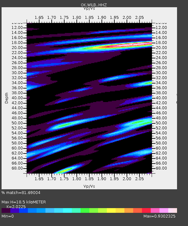
| Estimated Moho Depth: |
18.5 km |
| Estimated Crust Vp/Vs: |
2.02 |
| Assumed Crust Vp: |
6.498 km/s |
| Estimated Crust Vs: |
3.213 km/s |
| Estimated Crust Poisson's Ratio: |
0.34 |
|
| Radial Match: |
81.69004 % |
| Radial Bump: |
400 |
| Transverse Match: |
72.86773 % |
| Transverse Bump: |
400 |
| SOD ConfigId: |
31937991 |
| Insert Time: |
2023-11-14 12:54:23.023 +0000 |
| GWidth: |
2.5 |
| Max Bumps: |
400 |
| Tol: |
0.001 |
|

Signal To Noise
| Channel | StoN | STA | LTA |
| OK:WILB: :HHZ:20231031T12:44:03.579977Z | 2.7554004 | 4.8258545E-7 | 1.7514168E-7 |
| OK:WILB: :HHN:20231031T12:44:03.579977Z | 0.55799335 | 9.77242E-8 | 1.7513507E-7 |
| OK:WILB: :HHE:20231031T12:44:03.579977Z | 1.0596284 | 1.8206508E-7 | 1.7181975E-7 |
| Arrivals |
| Ps | 3.0 SECOND |
| PpPs | 8.3 SECOND |
| PsPs/PpSs | 11 SECOND |


