You are here: Home > Network List > PR - Puerto Rico Seismic Network (PRSN) & Puerto Rico Strong Motion Program (PRSMP) Stations List
> Station CELP Cerrilos Dam > Earthquake Result Viewer
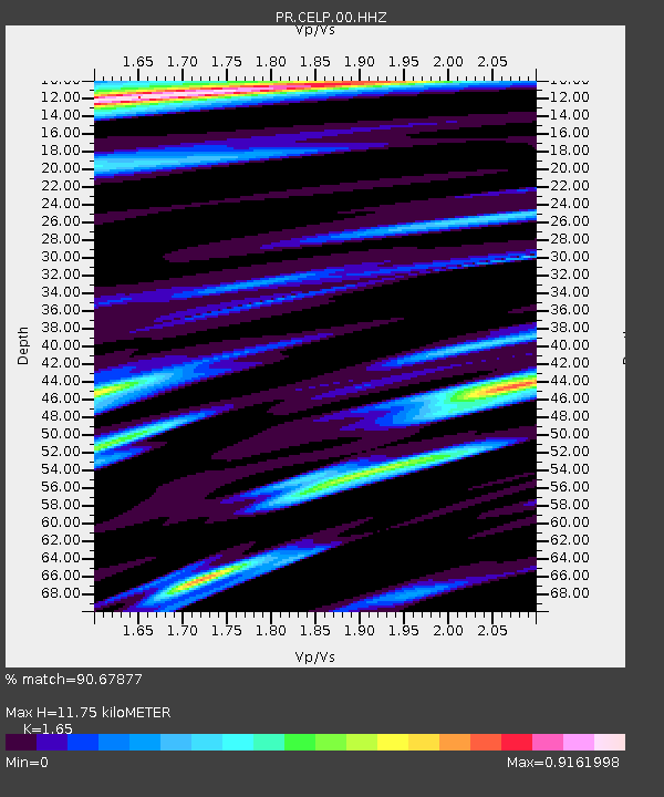
CELP Cerrilos Dam - Earthquake Result Viewer
| Earthquake location: |
Near Coast Of Central Chile |
| Earthquake latitude/longitude: |
-28.7/-71.6 |
| Earthquake time(UTC): |
2023/10/31 (304) 12:33:44 GMT |
| Earthquake Depth: |
41 km |
| Earthquake Magnitude: |
6.7 mww |
| Earthquake Catalog/Contributor: |
NEIC PDE/us |
|
| Network: |
PR Puerto Rico Seismic Network (PRSN) & Puerto Rico Strong Motion Program (PRSMP) |
| Station: |
CELP Cerrilos Dam |
| Lat/Lon: |
18.07 N/66.58 W |
| Elevation: |
196 m |
|
| Distance: |
46.8 deg |
| Az: |
6.523 deg |
| Baz: |
186.019 deg |
| Ray Param: |
0.070327036 |
| Estimated Moho Depth: |
11.75 km |
| Estimated Crust Vp/Vs: |
1.65 |
| Assumed Crust Vp: |
5.14 km/s |
| Estimated Crust Vs: |
3.115 km/s |
| Estimated Crust Poisson's Ratio: |
0.21 |
|
| Radial Match: |
90.67877 % |
| Radial Bump: |
368 |
| Transverse Match: |
78.03711 % |
| Transverse Bump: |
400 |
| SOD ConfigId: |
31937991 |
| Insert Time: |
2023-11-14 12:55:30.797 +0000 |
| GWidth: |
2.5 |
| Max Bumps: |
400 |
| Tol: |
0.001 |
|

Signal To Noise
| Channel | StoN | STA | LTA |
| PR:CELP:00:HHZ:20231031T12:41:39.339987Z | 13.376119 | 2.9621233E-6 | 2.2144863E-7 |
| PR:CELP:00:HH1:20231031T12:41:39.339987Z | 8.396877 | 1.3237157E-6 | 1.576438E-7 |
| PR:CELP:00:HH2:20231031T12:41:39.339987Z | 2.320672 | 3.5043473E-7 | 1.5100572E-7 |
| Arrivals |
| Ps | 1.5 SECOND |
| PpPs | 5.8 SECOND |
| PsPs/PpSs | 7.4 SECOND |


