You are here: Home > Network List > US - United States National Seismic Network Stations List
> Station EGMT Eagleton, Montana, USA > Earthquake Result Viewer
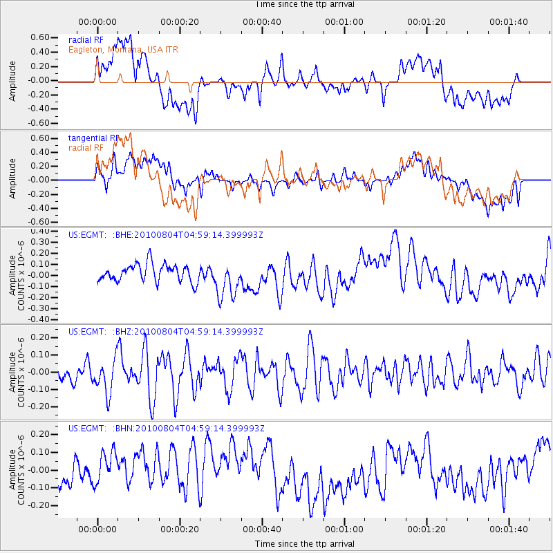
EGMT Eagleton, Montana, USA - Earthquake Result Viewer
*The percent match for this event was below the threshold and hence no stack was calculated.
| Earthquake location: |
South Of Fiji Islands |
| Earthquake latitude/longitude: |
-26.9/-177.2 |
| Earthquake time(UTC): |
2010/08/04 (216) 04:46:20 GMT |
| Earthquake Depth: |
18 km |
| Earthquake Magnitude: |
5.7 MB, 5.8 MS, 6.0 MW, 5.9 MW |
| Earthquake Catalog/Contributor: |
WHDF/NEIC |
|
| Network: |
US United States National Seismic Network |
| Station: |
EGMT Eagleton, Montana, USA |
| Lat/Lon: |
48.02 N/109.75 W |
| Elevation: |
1055 m |
|
| Distance: |
96.0 deg |
| Az: |
38.576 deg |
| Baz: |
236.035 deg |
| Ray Param: |
$rayparam |
*The percent match for this event was below the threshold and hence was not used in the summary stack. |
|
| Radial Match: |
41.249767 % |
| Radial Bump: |
400 |
| Transverse Match: |
39.238266 % |
| Transverse Bump: |
400 |
| SOD ConfigId: |
319893 |
| Insert Time: |
2011-01-05 15:53:32.682 +0000 |
| GWidth: |
2.5 |
| Max Bumps: |
400 |
| Tol: |
0.001 |
|
Signal To Noise
| Channel | StoN | STA | LTA |
| US:EGMT: :BHZ:20100804T04:59:14.399993Z | 1.8160487 | 1.0251131E-7 | 5.6447444E-8 |
| US:EGMT: :BHN:20100804T04:59:14.399993Z | 1.8043435 | 1.4633535E-7 | 8.110172E-8 |
| US:EGMT: :BHE:20100804T04:59:14.399993Z | 2.2399511 | 1.7529405E-7 | 7.8257976E-8 |
| Arrivals |
| Ps | |
| PpPs | |
| PsPs/PpSs | |


