You are here: Home > Network List > SC - New Mexico Tech Seismic Network Stations List
> Station GDL2 Guadalupe Mountains, New Mexico > Earthquake Result Viewer
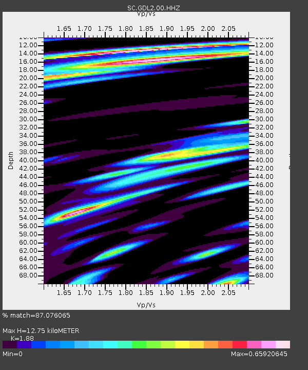
GDL2 Guadalupe Mountains, New Mexico - Earthquake Result Viewer
| Earthquake location: |
Near Coast Of Central Chile |
| Earthquake latitude/longitude: |
-28.7/-71.6 |
| Earthquake time(UTC): |
2023/10/31 (304) 12:33:44 GMT |
| Earthquake Depth: |
41 km |
| Earthquake Magnitude: |
6.7 mww |
| Earthquake Catalog/Contributor: |
NEIC PDE/us |
|
| Network: |
SC New Mexico Tech Seismic Network |
| Station: |
GDL2 Guadalupe Mountains, New Mexico |
| Lat/Lon: |
32.20 N/104.36 W |
| Elevation: |
1211 m |
|
| Distance: |
68.2 deg |
| Az: |
330.352 deg |
| Baz: |
149.179 deg |
| Ray Param: |
0.056417696 |
| Estimated Moho Depth: |
12.75 km |
| Estimated Crust Vp/Vs: |
1.88 |
| Assumed Crust Vp: |
6.232 km/s |
| Estimated Crust Vs: |
3.315 km/s |
| Estimated Crust Poisson's Ratio: |
0.30 |
|
| Radial Match: |
87.076065 % |
| Radial Bump: |
400 |
| Transverse Match: |
76.46969 % |
| Transverse Bump: |
400 |
| SOD ConfigId: |
31937991 |
| Insert Time: |
2023-11-14 12:57:02.111 +0000 |
| GWidth: |
2.5 |
| Max Bumps: |
400 |
| Tol: |
0.001 |
|

Signal To Noise
| Channel | StoN | STA | LTA |
| SC:GDL2:00:HHZ:20231031T12:44:09.414999Z | 7.153989 | 1.0067311E-7 | 1.4072306E-8 |
| SC:GDL2:00:HHN:20231031T12:44:09.414999Z | 2.735933 | 2.3522176E-8 | 8.597497E-9 |
| SC:GDL2:00:HHE:20231031T12:44:09.414999Z | 2.146584 | 1.3926137E-8 | 6.4875807E-9 |
| Arrivals |
| Ps | 1.9 SECOND |
| PpPs | 5.7 SECOND |
| PsPs/PpSs | 7.6 SECOND |


