You are here: Home > Network List > US - United States National Seismic Network Stations List
> Station MSO Missoula, Montana, USA > Earthquake Result Viewer
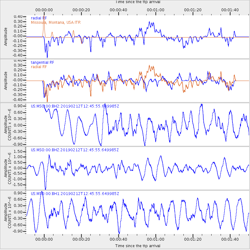
MSO Missoula, Montana, USA - Earthquake Result Viewer
*The percent match for this event was below the threshold and hence no stack was calculated.
| Earthquake location: |
Mariana Islands |
| Earthquake latitude/longitude: |
19.1/145.8 |
| Earthquake time(UTC): |
2019/02/12 (043) 12:34:15 GMT |
| Earthquake Depth: |
130 km |
| Earthquake Magnitude: |
5.9 mww |
| Earthquake Catalog/Contributor: |
NEIC PDE/us |
|
| Network: |
US United States National Seismic Network |
| Station: |
MSO Missoula, Montana, USA |
| Lat/Lon: |
46.83 N/113.94 W |
| Elevation: |
1264 m |
|
| Distance: |
83.1 deg |
| Az: |
42.883 deg |
| Baz: |
290.386 deg |
| Ray Param: |
$rayparam |
*The percent match for this event was below the threshold and hence was not used in the summary stack. |
|
| Radial Match: |
55.581535 % |
| Radial Bump: |
400 |
| Transverse Match: |
46.704983 % |
| Transverse Bump: |
400 |
| SOD ConfigId: |
3287751 |
| Insert Time: |
2019-02-26 12:56:53.738 +0000 |
| GWidth: |
2.5 |
| Max Bumps: |
400 |
| Tol: |
0.001 |
|
Signal To Noise
| Channel | StoN | STA | LTA |
| US:MSO:00:BHZ:20190212T12:45:55.649985Z | 2.013024 | 8.3732635E-7 | 4.1595445E-7 |
| US:MSO:00:BH1:20190212T12:45:55.649985Z | 1.1293471 | 4.3850773E-7 | 3.882843E-7 |
| US:MSO:00:BH2:20190212T12:45:55.649985Z | 1.4318161 | 7.070046E-7 | 4.9378167E-7 |
| Arrivals |
| Ps | |
| PpPs | |
| PsPs/PpSs | |


